You are here: Home > Network List > TA - USArray Transportable Network (new EarthScope stations) Stations List
> Station Z46A Louisville, MS, USA > Earthquake Result Viewer
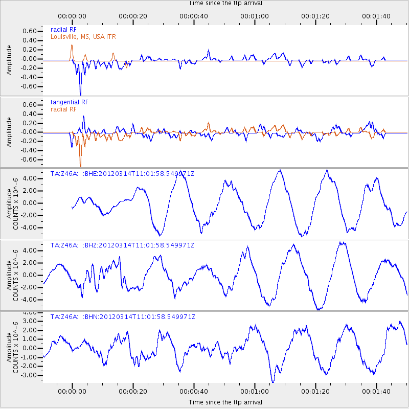
Z46A Louisville, MS, USA - Earthquake Result Viewer
*The percent match for this event was below the threshold and hence no stack was calculated.
| Earthquake location: |
Off East Coast Of Honshu, Japan |
| Earthquake latitude/longitude: |
40.8/144.8 |
| Earthquake time(UTC): |
2012/03/14 (074) 10:49:24 GMT |
| Earthquake Depth: |
10 km |
| Earthquake Magnitude: |
5.8 MB, 6.1 MW |
| Earthquake Catalog/Contributor: |
WHDF/NEIC |
|
| Network: |
TA USArray Transportable Network (new EarthScope stations) |
| Station: |
Z46A Louisville, MS, USA |
| Lat/Lon: |
33.19 N/88.94 W |
| Elevation: |
125 m |
|
| Distance: |
91.3 deg |
| Az: |
42.529 deg |
| Baz: |
322.253 deg |
| Ray Param: |
$rayparam |
*The percent match for this event was below the threshold and hence was not used in the summary stack. |
|
| Radial Match: |
89.16057 % |
| Radial Bump: |
400 |
| Transverse Match: |
69.0945 % |
| Transverse Bump: |
400 |
| SOD ConfigId: |
440406 |
| Insert Time: |
2012-05-25 23:43:18.790 +0000 |
| GWidth: |
2.5 |
| Max Bumps: |
400 |
| Tol: |
0.001 |
|
Signal To Noise
| Channel | StoN | STA | LTA |
| TA:Z46A: :BHZ:20120314T11:01:58.549971Z | 1.4981135 | 1.386954E-6 | 9.2580035E-7 |
| TA:Z46A: :BHN:20120314T11:01:58.549971Z | 0.7952324 | 6.316949E-7 | 7.943525E-7 |
| TA:Z46A: :BHE:20120314T11:01:58.549971Z | 2.874964 | 3.331131E-6 | 1.1586687E-6 |
| Arrivals |
| Ps | |
| PpPs | |
| PsPs/PpSs | |


