You are here: Home > Network List > TA - USArray Transportable Network (new EarthScope stations) Stations List
> Station I41A Arkdale, WI, USA > Earthquake Result Viewer
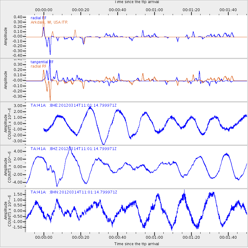
I41A Arkdale, WI, USA - Earthquake Result Viewer
*The percent match for this event was below the threshold and hence no stack was calculated.
| Earthquake location: |
Off East Coast Of Honshu, Japan |
| Earthquake latitude/longitude: |
40.8/144.8 |
| Earthquake time(UTC): |
2012/03/14 (074) 10:49:24 GMT |
| Earthquake Depth: |
10 km |
| Earthquake Magnitude: |
5.8 MB, 6.1 MW |
| Earthquake Catalog/Contributor: |
WHDF/NEIC |
|
| Network: |
TA USArray Transportable Network (new EarthScope stations) |
| Station: |
I41A Arkdale, WI, USA |
| Lat/Lon: |
44.06 N/89.87 W |
| Elevation: |
289 m |
|
| Distance: |
82.3 deg |
| Az: |
36.387 deg |
| Baz: |
321.328 deg |
| Ray Param: |
$rayparam |
*The percent match for this event was below the threshold and hence was not used in the summary stack. |
|
| Radial Match: |
85.153366 % |
| Radial Bump: |
400 |
| Transverse Match: |
71.63801 % |
| Transverse Bump: |
338 |
| SOD ConfigId: |
440406 |
| Insert Time: |
2012-05-25 23:44:02.105 +0000 |
| GWidth: |
2.5 |
| Max Bumps: |
400 |
| Tol: |
0.001 |
|
Signal To Noise
| Channel | StoN | STA | LTA |
| TA:I41A: :BHZ:20120314T11:01:14.799971Z | 0.61814713 | 1.61348E-6 | 2.6101877E-6 |
| TA:I41A: :BHN:20120314T11:01:14.799971Z | 0.9395624 | 4.2045838E-7 | 4.4750448E-7 |
| TA:I41A: :BHE:20120314T11:01:14.799971Z | 2.1795182 | 2.5730606E-6 | 1.1805639E-6 |
| Arrivals |
| Ps | |
| PpPs | |
| PsPs/PpSs | |


