You are here: Home > Network List > TA - USArray Transportable Network (new EarthScope stations) Stations List
> Station I39A Houston, MN, USA > Earthquake Result Viewer
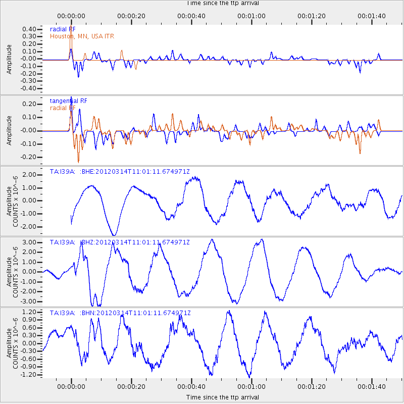
I39A Houston, MN, USA - Earthquake Result Viewer
*The percent match for this event was below the threshold and hence no stack was calculated.
| Earthquake location: |
Off East Coast Of Honshu, Japan |
| Earthquake latitude/longitude: |
40.8/144.8 |
| Earthquake time(UTC): |
2012/03/14 (074) 10:49:24 GMT |
| Earthquake Depth: |
10 km |
| Earthquake Magnitude: |
5.8 MB, 6.1 MW |
| Earthquake Catalog/Contributor: |
WHDF/NEIC |
|
| Network: |
TA USArray Transportable Network (new EarthScope stations) |
| Station: |
I39A Houston, MN, USA |
| Lat/Lon: |
43.85 N/91.52 W |
| Elevation: |
393 m |
|
| Distance: |
81.7 deg |
| Az: |
37.453 deg |
| Baz: |
320.333 deg |
| Ray Param: |
$rayparam |
*The percent match for this event was below the threshold and hence was not used in the summary stack. |
|
| Radial Match: |
66.45713 % |
| Radial Bump: |
400 |
| Transverse Match: |
61.247383 % |
| Transverse Bump: |
400 |
| SOD ConfigId: |
440406 |
| Insert Time: |
2012-05-25 23:44:16.446 +0000 |
| GWidth: |
2.5 |
| Max Bumps: |
400 |
| Tol: |
0.001 |
|
Signal To Noise
| Channel | StoN | STA | LTA |
| TA:I39A: :BHZ:20120314T11:01:11.674971Z | 1.7270001 | 1.5395906E-6 | 8.914826E-7 |
| TA:I39A: :BHN:20120314T11:01:11.674971Z | 0.8520731 | 6.111672E-7 | 7.1727084E-7 |
| TA:I39A: :BHE:20120314T11:01:11.674971Z | 0.8166648 | 9.755017E-7 | 1.1944946E-6 |
| Arrivals |
| Ps | |
| PpPs | |
| PsPs/PpSs | |


