You are here: Home > Network List > TA - USArray Transportable Network (new EarthScope stations) Stations List
> Station C40A Isle Royale National Park, MI, USA > Earthquake Result Viewer
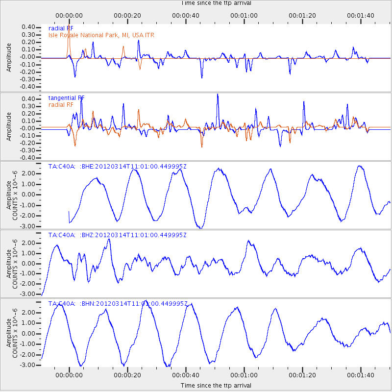
C40A Isle Royale National Park, MI, USA - Earthquake Result Viewer
*The percent match for this event was below the threshold and hence no stack was calculated.
| Earthquake location: |
Off East Coast Of Honshu, Japan |
| Earthquake latitude/longitude: |
40.8/144.8 |
| Earthquake time(UTC): |
2012/03/14 (074) 10:49:24 GMT |
| Earthquake Depth: |
10 km |
| Earthquake Magnitude: |
5.8 MB, 6.1 MW |
| Earthquake Catalog/Contributor: |
WHDF/NEIC |
|
| Network: |
TA USArray Transportable Network (new EarthScope stations) |
| Station: |
C40A Isle Royale National Park, MI, USA |
| Lat/Lon: |
47.92 N/89.15 W |
| Elevation: |
216 m |
|
| Distance: |
79.6 deg |
| Az: |
33.553 deg |
| Baz: |
321.397 deg |
| Ray Param: |
$rayparam |
*The percent match for this event was below the threshold and hence was not used in the summary stack. |
|
| Radial Match: |
86.94583 % |
| Radial Bump: |
286 |
| Transverse Match: |
80.62373 % |
| Transverse Bump: |
305 |
| SOD ConfigId: |
440406 |
| Insert Time: |
2012-05-25 23:44:53.697 +0000 |
| GWidth: |
2.5 |
| Max Bumps: |
400 |
| Tol: |
0.001 |
|
Signal To Noise
| Channel | StoN | STA | LTA |
| TA:C40A: :BHZ:20120314T11:01:00.449995Z | 0.3260303 | 7.849554E-7 | 2.4076148E-6 |
| TA:C40A: :BHN:20120314T11:01:00.449995Z | 1.1938872 | 1.7979311E-6 | 1.5059471E-6 |
| TA:C40A: :BHE:20120314T11:01:00.449995Z | 1.1218076 | 1.7615719E-6 | 1.5702977E-6 |
| Arrivals |
| Ps | |
| PpPs | |
| PsPs/PpSs | |


