You are here: Home > Network List > TA - USArray Transportable Network (new EarthScope stations) Stations List
> Station X48A Hartselle, AL, USA > Earthquake Result Viewer
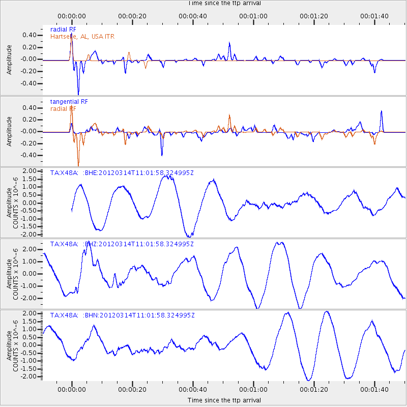
X48A Hartselle, AL, USA - Earthquake Result Viewer
*The percent match for this event was below the threshold and hence no stack was calculated.
| Earthquake location: |
Off East Coast Of Honshu, Japan |
| Earthquake latitude/longitude: |
40.8/144.8 |
| Earthquake time(UTC): |
2012/03/14 (074) 10:49:24 GMT |
| Earthquake Depth: |
10 km |
| Earthquake Magnitude: |
5.8 MB, 6.1 MW |
| Earthquake Catalog/Contributor: |
WHDF/NEIC |
|
| Network: |
TA USArray Transportable Network (new EarthScope stations) |
| Station: |
X48A Hartselle, AL, USA |
| Lat/Lon: |
34.45 N/87.05 W |
| Elevation: |
180 m |
|
| Distance: |
91.2 deg |
| Az: |
40.513 deg |
| Baz: |
323.348 deg |
| Ray Param: |
$rayparam |
*The percent match for this event was below the threshold and hence was not used in the summary stack. |
|
| Radial Match: |
88.11111 % |
| Radial Bump: |
400 |
| Transverse Match: |
50.034527 % |
| Transverse Bump: |
354 |
| SOD ConfigId: |
440406 |
| Insert Time: |
2012-05-25 23:45:23.184 +0000 |
| GWidth: |
2.5 |
| Max Bumps: |
400 |
| Tol: |
0.001 |
|
Signal To Noise
| Channel | StoN | STA | LTA |
| TA:X48A: :BHZ:20120314T11:01:58.324995Z | 1.1112552 | 1.4824008E-6 | 1.3339877E-6 |
| TA:X48A: :BHN:20120314T11:01:58.324995Z | 0.5725092 | 5.709308E-7 | 9.972431E-7 |
| TA:X48A: :BHE:20120314T11:01:58.324995Z | 1.6941788 | 1.5870069E-6 | 9.3674106E-7 |
| Arrivals |
| Ps | |
| PpPs | |
| PsPs/PpSs | |


