You are here: Home > Network List > TA - USArray Transportable Network (new EarthScope stations) Stations List
> Station 657A Interlachen, FL, USA > Earthquake Result Viewer
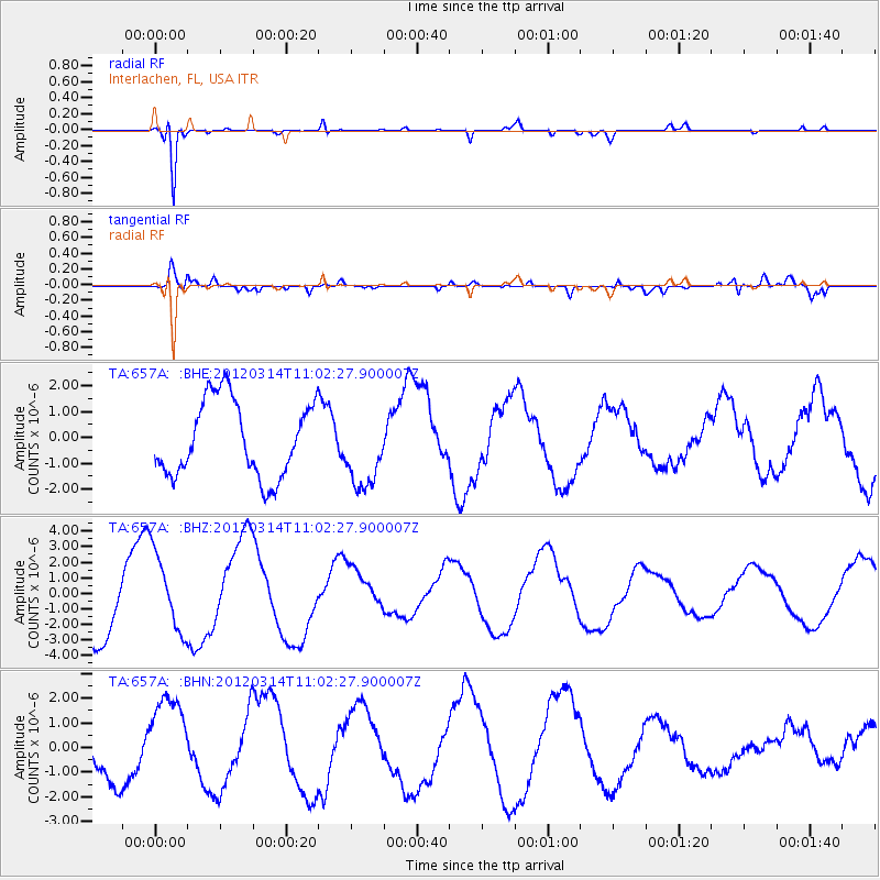
657A Interlachen, FL, USA - Earthquake Result Viewer
*The percent match for this event was below the threshold and hence no stack was calculated.
| Earthquake location: |
Off East Coast Of Honshu, Japan |
| Earthquake latitude/longitude: |
40.8/144.8 |
| Earthquake time(UTC): |
2012/03/14 (074) 10:49:24 GMT |
| Earthquake Depth: |
10 km |
| Earthquake Magnitude: |
5.8 MB, 6.1 MW |
| Earthquake Catalog/Contributor: |
WHDF/NEIC |
|
| Network: |
TA USArray Transportable Network (new EarthScope stations) |
| Station: |
657A Interlachen, FL, USA |
| Lat/Lon: |
29.59 N/81.87 W |
| Elevation: |
34 m |
|
| Distance: |
97.7 deg |
| Az: |
39.716 deg |
| Baz: |
326.147 deg |
| Ray Param: |
$rayparam |
*The percent match for this event was below the threshold and hence was not used in the summary stack. |
|
| Radial Match: |
94.89348 % |
| Radial Bump: |
233 |
| Transverse Match: |
63.363834 % |
| Transverse Bump: |
400 |
| SOD ConfigId: |
440406 |
| Insert Time: |
2012-05-25 23:45:53.344 +0000 |
| GWidth: |
2.5 |
| Max Bumps: |
400 |
| Tol: |
0.001 |
|
Signal To Noise
| Channel | StoN | STA | LTA |
| TA:657A: :BHZ:20120314T11:02:27.900007Z | 1.3038213 | 2.5110219E-6 | 1.9258944E-6 |
| TA:657A: :BHN:20120314T11:02:27.900007Z | 2.626506 | 1.7241731E-6 | 6.564512E-7 |
| TA:657A: :BHE:20120314T11:02:27.900007Z | 1.0073423 | 1.4688476E-6 | 1.4581414E-6 |
| Arrivals |
| Ps | |
| PpPs | |
| PsPs/PpSs | |


