You are here: Home > Network List > TA - USArray Transportable Network (new EarthScope stations) Stations List
> Station Y46A Houston, MS, USA > Earthquake Result Viewer
Y46A Houston, MS, USA - Earthquake Result Viewer
| Earthquake location: |
Off East Coast Of Honshu, Japan |
| Earthquake latitude/longitude: |
40.8/144.8 |
| Earthquake time(UTC): |
2012/03/14 (074) 10:57:40 GMT |
| Earthquake Depth: |
12 km |
| Earthquake Magnitude: |
5.6 MB |
| Earthquake Catalog/Contributor: |
WHDF/NEIC |
|
| Network: |
TA USArray Transportable Network (new EarthScope stations) |
| Station: |
Y46A Houston, MS, USA |
| Lat/Lon: |
33.88 N/88.86 W |
| Elevation: |
109 m |
|
| Distance: |
90.8 deg |
| Az: |
42.083 deg |
| Baz: |
322.265 deg |
| Ray Param: |
0.041648738 |
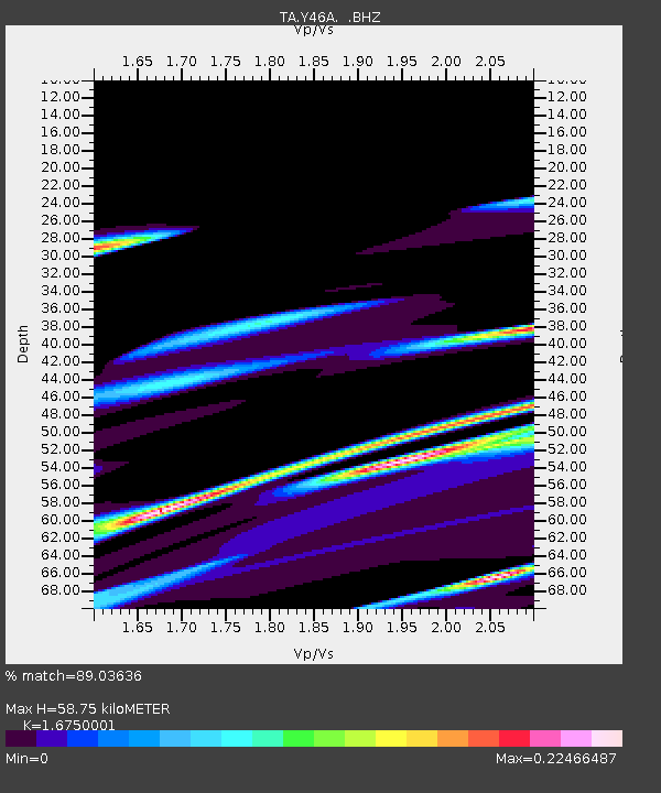
| Estimated Moho Depth: |
58.75 km |
| Estimated Crust Vp/Vs: |
1.68 |
| Assumed Crust Vp: |
6.201 km/s |
| Estimated Crust Vs: |
3.702 km/s |
| Estimated Crust Poisson's Ratio: |
0.22 |
|
| Radial Match: |
89.03636 % |
| Radial Bump: |
400 |
| Transverse Match: |
91.94623 % |
| Transverse Bump: |
280 |
| SOD ConfigId: |
440406 |
| Insert Time: |
2012-05-26 00:04:33.843 +0000 |
| GWidth: |
2.5 |
| Max Bumps: |
400 |
| Tol: |
0.001 |
|
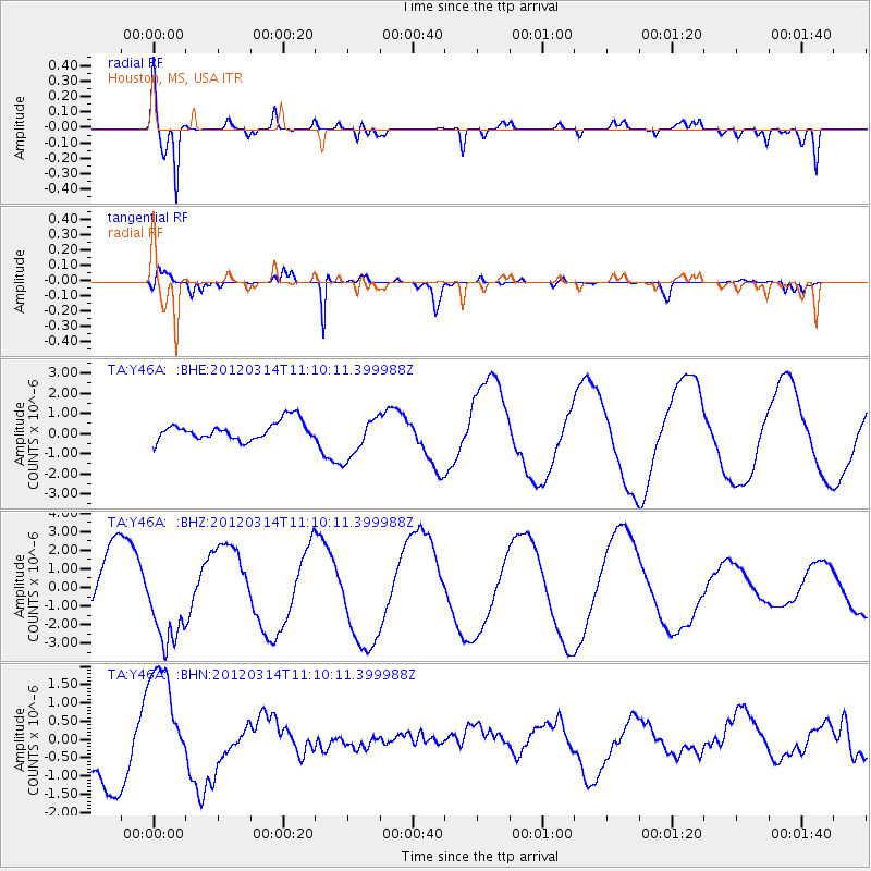
Signal To Noise
| Channel | StoN | STA | LTA |
| TA:Y46A: :BHZ:20120314T11:10:11.399988Z | 1.4343917 | 2.2768502E-6 | 1.587328E-6 |
| TA:Y46A: :BHN:20120314T11:10:11.399988Z | 1.453275 | 1.5769134E-6 | 1.0850757E-6 |
| TA:Y46A: :BHE:20120314T11:10:11.399988Z | 2.3114614 | 1.0542808E-6 | 4.5611003E-7 |
| Arrivals |
| Ps | 6.5 SECOND |
| PpPs | 25 SECOND |
| PsPs/PpSs | 31 SECOND |


