You are here: Home > Network List > TA - USArray Transportable Network (new EarthScope stations) Stations List
> Station S43A Fulton Ridge, Patton, MO, USA > Earthquake Result Viewer
S43A Fulton Ridge, Patton, MO, USA - Earthquake Result Viewer
| Earthquake location: |
Off East Coast Of Honshu, Japan |
| Earthquake latitude/longitude: |
40.8/144.8 |
| Earthquake time(UTC): |
2012/03/14 (074) 10:57:40 GMT |
| Earthquake Depth: |
12 km |
| Earthquake Magnitude: |
5.6 MB |
| Earthquake Catalog/Contributor: |
WHDF/NEIC |
|
| Network: |
TA USArray Transportable Network (new EarthScope stations) |
| Station: |
S43A Fulton Ridge, Patton, MO, USA |
| Lat/Lon: |
37.57 N/90.08 W |
| Elevation: |
263 m |
|
| Distance: |
87.3 deg |
| Az: |
40.592 deg |
| Baz: |
321.531 deg |
| Ray Param: |
0.043439325 |
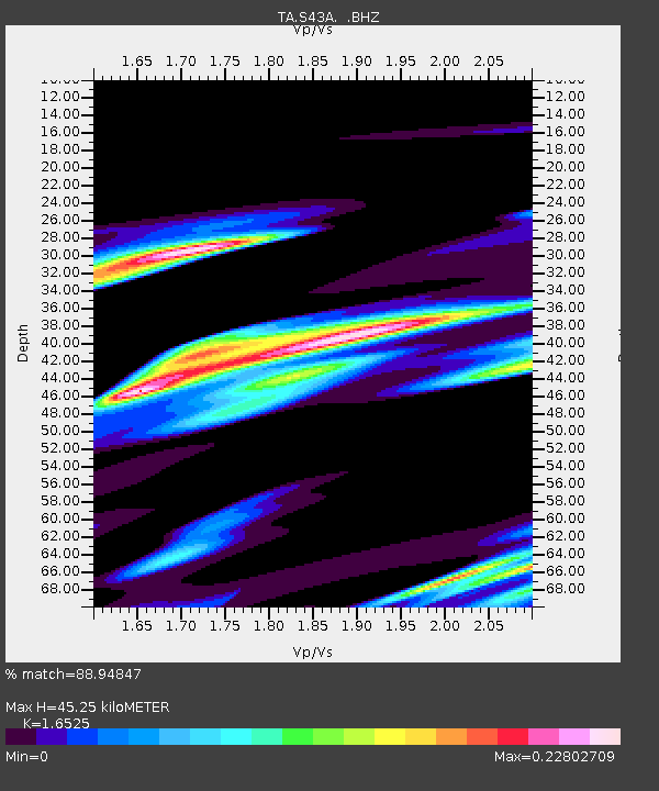
| Estimated Moho Depth: |
45.25 km |
| Estimated Crust Vp/Vs: |
1.65 |
| Assumed Crust Vp: |
6.53 km/s |
| Estimated Crust Vs: |
3.952 km/s |
| Estimated Crust Poisson's Ratio: |
0.21 |
|
| Radial Match: |
88.94847 % |
| Radial Bump: |
400 |
| Transverse Match: |
79.806496 % |
| Transverse Bump: |
382 |
| SOD ConfigId: |
440406 |
| Insert Time: |
2012-05-26 00:05:01.201 +0000 |
| GWidth: |
2.5 |
| Max Bumps: |
400 |
| Tol: |
0.001 |
|

Signal To Noise
| Channel | StoN | STA | LTA |
| TA:S43A: :BHZ:20120314T11:09:54.925012Z | 0.84941113 | 2.0775888E-6 | 2.4459166E-6 |
| TA:S43A: :BHN:20120314T11:09:54.925012Z | 0.7814279 | 4.3792411E-7 | 5.6041523E-7 |
| TA:S43A: :BHE:20120314T11:09:54.925012Z | 1.568445 | 2.274852E-6 | 1.4503869E-6 |
| Arrivals |
| Ps | 4.6 SECOND |
| PpPs | 18 SECOND |
| PsPs/PpSs | 23 SECOND |


