You are here: Home > Network List > TA - USArray Transportable Network (new EarthScope stations) Stations List
> Station L41A Preston, IA, USA > Earthquake Result Viewer
L41A Preston, IA, USA - Earthquake Result Viewer
| Earthquake location: |
Off East Coast Of Honshu, Japan |
| Earthquake latitude/longitude: |
40.8/144.8 |
| Earthquake time(UTC): |
2012/03/14 (074) 10:57:40 GMT |
| Earthquake Depth: |
12 km |
| Earthquake Magnitude: |
5.6 MB |
| Earthquake Catalog/Contributor: |
WHDF/NEIC |
|
| Network: |
TA USArray Transportable Network (new EarthScope stations) |
| Station: |
L41A Preston, IA, USA |
| Lat/Lon: |
42.08 N/90.50 W |
| Elevation: |
238 m |
|
| Distance: |
83.6 deg |
| Az: |
38.025 deg |
| Baz: |
321.056 deg |
| Ray Param: |
0.046100136 |
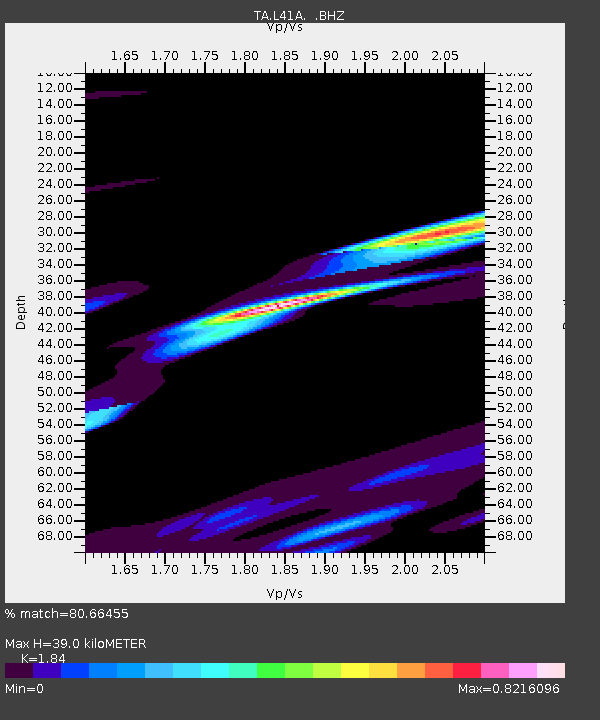
| Estimated Moho Depth: |
39.0 km |
| Estimated Crust Vp/Vs: |
1.84 |
| Assumed Crust Vp: |
6.53 km/s |
| Estimated Crust Vs: |
3.549 km/s |
| Estimated Crust Poisson's Ratio: |
0.29 |
|
| Radial Match: |
80.66455 % |
| Radial Bump: |
400 |
| Transverse Match: |
58.429394 % |
| Transverse Bump: |
400 |
| SOD ConfigId: |
440406 |
| Insert Time: |
2012-05-26 00:05:07.638 +0000 |
| GWidth: |
2.5 |
| Max Bumps: |
400 |
| Tol: |
0.001 |
|

Signal To Noise
| Channel | StoN | STA | LTA |
| TA:L41A: :BHZ:20120314T11:09:36.475Z | 2.9126418 | 2.1101907E-6 | 7.244937E-7 |
| TA:L41A: :BHN:20120314T11:09:36.475Z | 2.3641455 | 1.72567E-6 | 7.299339E-7 |
| TA:L41A: :BHE:20120314T11:09:36.475Z | 1.1417829 | 1.607388E-6 | 1.4077877E-6 |
| Arrivals |
| Ps | 5.1 SECOND |
| PpPs | 17 SECOND |
| PsPs/PpSs | 22 SECOND |


