You are here: Home > Network List > CN - Canadian National Seismograph Network Stations List
> Station INK INUVIK, NT, CANADA.ANADA > Earthquake Result Viewer
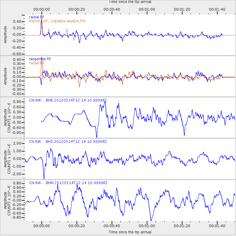
INK INUVIK, NT, CANADA.ANADA - Earthquake Result Viewer
*The percent match for this event was below the threshold and hence no stack was calculated.
| Earthquake location: |
Near East Coast Of Honshu, Japan |
| Earthquake latitude/longitude: |
35.7/140.7 |
| Earthquake time(UTC): |
2012/03/14 (074) 12:05:04 GMT |
| Earthquake Depth: |
10 km |
| Earthquake Magnitude: |
5.7 MB, 5.6 MS, 6.0 MW |
| Earthquake Catalog/Contributor: |
WHDF/NEIC |
|
| Network: |
CN Canadian National Seismograph Network |
| Station: |
INK INUVIK, NT, CANADA.ANADA |
| Lat/Lon: |
68.31 N/133.52 W |
| Elevation: |
40 m |
|
| Distance: |
55.8 deg |
| Az: |
26.618 deg |
| Baz: |
281.175 deg |
| Ray Param: |
$rayparam |
*The percent match for this event was below the threshold and hence was not used in the summary stack. |
|
| Radial Match: |
70.849815 % |
| Radial Bump: |
400 |
| Transverse Match: |
51.348724 % |
| Transverse Bump: |
400 |
| SOD ConfigId: |
440406 |
| Insert Time: |
2012-05-26 00:20:15.475 +0000 |
| GWidth: |
2.5 |
| Max Bumps: |
400 |
| Tol: |
0.001 |
|
Signal To Noise
| Channel | StoN | STA | LTA |
| CN:INK: :BHZ:20120314T12:14:10.99998Z | 2.3059058 | 9.954117E-7 | 4.3167927E-7 |
| CN:INK: :BHN:20120314T12:14:10.99998Z | 0.54262733 | 1.5322865E-7 | 2.8238287E-7 |
| CN:INK: :BHE:20120314T12:14:10.99998Z | 3.0541954 | 6.3609104E-7 | 2.0826795E-7 |
| Arrivals |
| Ps | |
| PpPs | |
| PsPs/PpSs | |


