You are here: Home > Network List > IW - Intermountain West Stations List
> Station MOOW Moose Ponds, Wyoming, USA > Earthquake Result Viewer
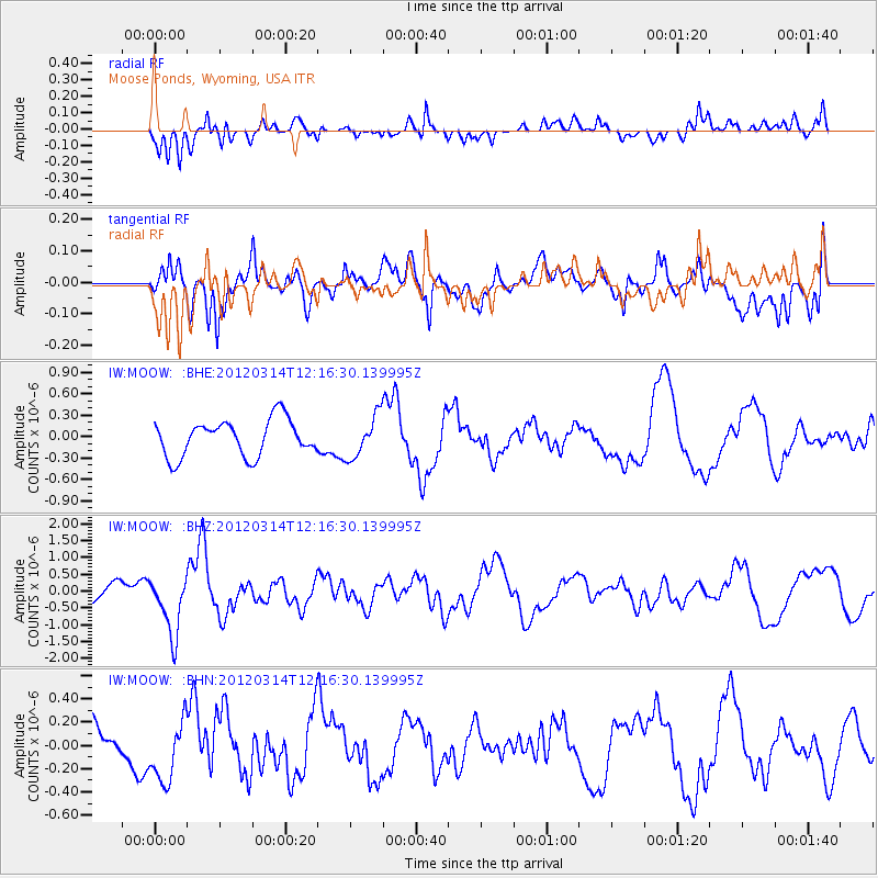
MOOW Moose Ponds, Wyoming, USA - Earthquake Result Viewer
*The percent match for this event was below the threshold and hence no stack was calculated.
| Earthquake location: |
Near East Coast Of Honshu, Japan |
| Earthquake latitude/longitude: |
35.7/140.7 |
| Earthquake time(UTC): |
2012/03/14 (074) 12:05:04 GMT |
| Earthquake Depth: |
10 km |
| Earthquake Magnitude: |
5.7 MB, 5.6 MS, 6.0 MW |
| Earthquake Catalog/Contributor: |
WHDF/NEIC |
|
| Network: |
IW Intermountain West |
| Station: |
MOOW Moose Ponds, Wyoming, USA |
| Lat/Lon: |
43.75 N/110.74 W |
| Elevation: |
2128 m |
|
| Distance: |
77.7 deg |
| Az: |
44.672 deg |
| Baz: |
307.838 deg |
| Ray Param: |
$rayparam |
*The percent match for this event was below the threshold and hence was not used in the summary stack. |
|
| Radial Match: |
67.46447 % |
| Radial Bump: |
400 |
| Transverse Match: |
69.643166 % |
| Transverse Bump: |
400 |
| SOD ConfigId: |
440406 |
| Insert Time: |
2012-05-26 00:22:50.843 +0000 |
| GWidth: |
2.5 |
| Max Bumps: |
400 |
| Tol: |
0.001 |
|
Signal To Noise
| Channel | StoN | STA | LTA |
| IW:MOOW: :BHZ:20120314T12:16:30.139995Z | 3.370697 | 8.7048875E-7 | 2.5825187E-7 |
| IW:MOOW: :BHN:20120314T12:16:30.139995Z | 0.93272763 | 2.8158152E-7 | 3.018904E-7 |
| IW:MOOW: :BHE:20120314T12:16:30.139995Z | 1.1645659 | 2.9600815E-7 | 2.5417896E-7 |
| Arrivals |
| Ps | |
| PpPs | |
| PsPs/PpSs | |


