You are here: Home > Network List > TA - USArray Transportable Network (new EarthScope stations) Stations List
> Station T25A Trinidad, CO, USA > Earthquake Result Viewer
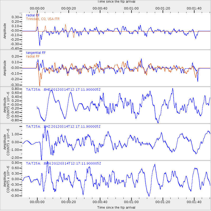
T25A Trinidad, CO, USA - Earthquake Result Viewer
*The percent match for this event was below the threshold and hence no stack was calculated.
| Earthquake location: |
Near East Coast Of Honshu, Japan |
| Earthquake latitude/longitude: |
35.7/140.7 |
| Earthquake time(UTC): |
2012/03/14 (074) 12:05:04 GMT |
| Earthquake Depth: |
10 km |
| Earthquake Magnitude: |
5.7 MB, 5.6 MS, 6.0 MW |
| Earthquake Catalog/Contributor: |
WHDF/NEIC |
|
| Network: |
TA USArray Transportable Network (new EarthScope stations) |
| Station: |
T25A Trinidad, CO, USA |
| Lat/Lon: |
37.14 N/104.41 W |
| Elevation: |
2017 m |
|
| Distance: |
85.7 deg |
| Az: |
46.63 deg |
| Baz: |
312.223 deg |
| Ray Param: |
$rayparam |
*The percent match for this event was below the threshold and hence was not used in the summary stack. |
|
| Radial Match: |
65.9744 % |
| Radial Bump: |
400 |
| Transverse Match: |
65.96284 % |
| Transverse Bump: |
400 |
| SOD ConfigId: |
440406 |
| Insert Time: |
2012-05-26 00:28:49.894 +0000 |
| GWidth: |
2.5 |
| Max Bumps: |
400 |
| Tol: |
0.001 |
|
Signal To Noise
| Channel | StoN | STA | LTA |
| TA:T25A: :BHZ:20120314T12:17:11.900005Z | 3.5389478 | 9.0953364E-7 | 2.570068E-7 |
| TA:T25A: :BHN:20120314T12:17:11.900005Z | 1.1522913 | 2.8103085E-7 | 2.438887E-7 |
| TA:T25A: :BHE:20120314T12:17:11.900005Z | 0.29006922 | 1.3508017E-7 | 4.6568255E-7 |
| Arrivals |
| Ps | |
| PpPs | |
| PsPs/PpSs | |


