You are here: Home > Network List > TA - USArray Transportable Network (new EarthScope stations) Stations List
> Station G36A St. Michael, MN, USA > Earthquake Result Viewer
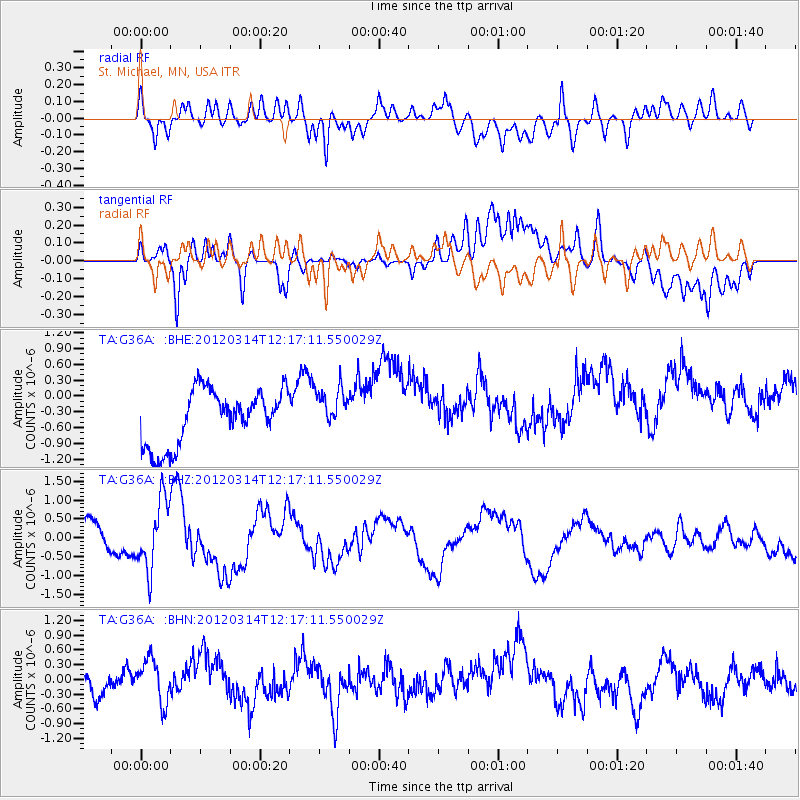
G36A St. Michael, MN, USA - Earthquake Result Viewer
*The percent match for this event was below the threshold and hence no stack was calculated.
| Earthquake location: |
Near East Coast Of Honshu, Japan |
| Earthquake latitude/longitude: |
35.7/140.7 |
| Earthquake time(UTC): |
2012/03/14 (074) 12:05:04 GMT |
| Earthquake Depth: |
10 km |
| Earthquake Magnitude: |
5.7 MB, 5.6 MS, 6.0 MW |
| Earthquake Catalog/Contributor: |
WHDF/NEIC |
|
| Network: |
TA USArray Transportable Network (new EarthScope stations) |
| Station: |
G36A St. Michael, MN, USA |
| Lat/Lon: |
45.23 N/93.75 W |
| Elevation: |
293 m |
|
| Distance: |
85.6 deg |
| Az: |
35.208 deg |
| Baz: |
318.376 deg |
| Ray Param: |
$rayparam |
*The percent match for this event was below the threshold and hence was not used in the summary stack. |
|
| Radial Match: |
57.05371 % |
| Radial Bump: |
400 |
| Transverse Match: |
48.165054 % |
| Transverse Bump: |
400 |
| SOD ConfigId: |
440406 |
| Insert Time: |
2012-05-26 00:33:45.962 +0000 |
| GWidth: |
2.5 |
| Max Bumps: |
400 |
| Tol: |
0.001 |
|
Signal To Noise
| Channel | StoN | STA | LTA |
| TA:G36A: :BHZ:20120314T12:17:11.550029Z | 2.2621632 | 9.149221E-7 | 4.0444567E-7 |
| TA:G36A: :BHN:20120314T12:17:11.550029Z | 1.2488011 | 5.424899E-7 | 4.3440855E-7 |
| TA:G36A: :BHE:20120314T12:17:11.550029Z | 0.7643064 | 3.9632067E-7 | 5.1853635E-7 |
| Arrivals |
| Ps | |
| PpPs | |
| PsPs/PpSs | |


