You are here: Home > Network List > G - GEOSCOPE Stations List
> Station INU Inuyama, Japan > Earthquake Result Viewer
INU Inuyama, Japan - Earthquake Result Viewer
| Earthquake location: |
Hindu Kush Region, Afghanistan |
| Earthquake latitude/longitude: |
36.1/70.5 |
| Earthquake time(UTC): |
1991/01/31 (031) 23:03:34 GMT |
| Earthquake Depth: |
152 km |
| Earthquake Magnitude: |
6.4 MB, 6.6 UNKNOWN |
| Earthquake Catalog/Contributor: |
WHDF/NEIC |
|
| Network: |
G GEOSCOPE |
| Station: |
INU Inuyama, Japan |
| Lat/Lon: |
35.35 N/137.03 E |
| Elevation: |
132 m |
|
| Distance: |
53.0 deg |
| Az: |
69.792 deg |
| Baz: |
291.533 deg |
| Ray Param: |
0.065837264 |
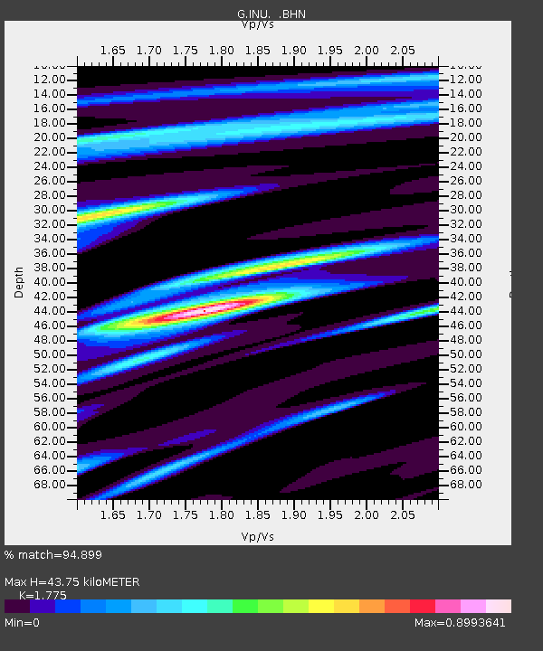
| Estimated Moho Depth: |
43.75 km |
| Estimated Crust Vp/Vs: |
1.77 |
| Assumed Crust Vp: |
6.461 km/s |
| Estimated Crust Vs: |
3.64 km/s |
| Estimated Crust Poisson's Ratio: |
0.27 |
|
| Radial Match: |
94.899 % |
| Radial Bump: |
400 |
| Transverse Match: |
92.9384 % |
| Transverse Bump: |
400 |
| SOD ConfigId: |
16938 |
| Insert Time: |
2010-02-26 23:22:22.506 +0000 |
| GWidth: |
2.5 |
| Max Bumps: |
400 |
| Tol: |
0.001 |
|

Signal To Noise
| Channel | StoN | STA | LTA |
| G:INU: :BHN:19910131T23:12:05.699011Z | 3.1761441 | 6.068531E-7 | 1.91066E-7 |
| G:INU: :BHE:19910131T23:12:05.699011Z | 7.8897815 | 1.5532261E-6 | 1.9686554E-7 |
| G:INU: :BHZ:19910131T23:12:05.699011Z | 13.690481 | 3.2251387E-6 | 2.3557527E-7 |
| Arrivals |
| Ps | 5.5 SECOND |
| PpPs | 18 SECOND |
| PsPs/PpSs | 23 SECOND |


