You are here: Home > Network List > G - GEOSCOPE Stations List
> Station INU Inuyama, Japan > Earthquake Result Viewer
INU Inuyama, Japan - Earthquake Result Viewer
| Earthquake location: |
Solomon Islands |
| Earthquake latitude/longitude: |
-9.9/159.1 |
| Earthquake time(UTC): |
1991/02/09 (040) 16:18:58 GMT |
| Earthquake Depth: |
10 km |
| Earthquake Magnitude: |
6.3 MB, 6.9 MS, 6.8 UNKNOWN |
| Earthquake Catalog/Contributor: |
WHDF/NEIC |
|
| Network: |
G GEOSCOPE |
| Station: |
INU Inuyama, Japan |
| Lat/Lon: |
35.35 N/137.03 E |
| Elevation: |
132 m |
|
| Distance: |
49.6 deg |
| Az: |
336.209 deg |
| Baz: |
150.903 deg |
| Ray Param: |
0.06861946 |
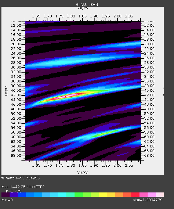
| Estimated Moho Depth: |
42.25 km |
| Estimated Crust Vp/Vs: |
1.77 |
| Assumed Crust Vp: |
6.461 km/s |
| Estimated Crust Vs: |
3.64 km/s |
| Estimated Crust Poisson's Ratio: |
0.27 |
|
| Radial Match: |
95.734955 % |
| Radial Bump: |
272 |
| Transverse Match: |
88.63431 % |
| Transverse Bump: |
400 |
| SOD ConfigId: |
16938 |
| Insert Time: |
2010-02-26 23:22:24.169 +0000 |
| GWidth: |
2.5 |
| Max Bumps: |
400 |
| Tol: |
0.001 |
|

Signal To Noise
| Channel | StoN | STA | LTA |
| G:INU: :BHN:19910209T16:27:18.400006Z | 3.7831063 | 1.1084486E-6 | 2.929996E-7 |
| G:INU: :BHE:19910209T16:27:18.400006Z | 4.0017905 | 6.762763E-7 | 1.6899344E-7 |
| G:INU: :BHZ:19910209T16:27:18.400006Z | 9.292757 | 2.789933E-6 | 3.0022662E-7 |
| Arrivals |
| Ps | 5.4 SECOND |
| PpPs | 17 SECOND |
| PsPs/PpSs | 22 SECOND |


