You are here: Home > Network List > TA - USArray Transportable Network (new EarthScope stations) Stations List
> Station L02D Cave Junction, OR, USA > Earthquake Result Viewer
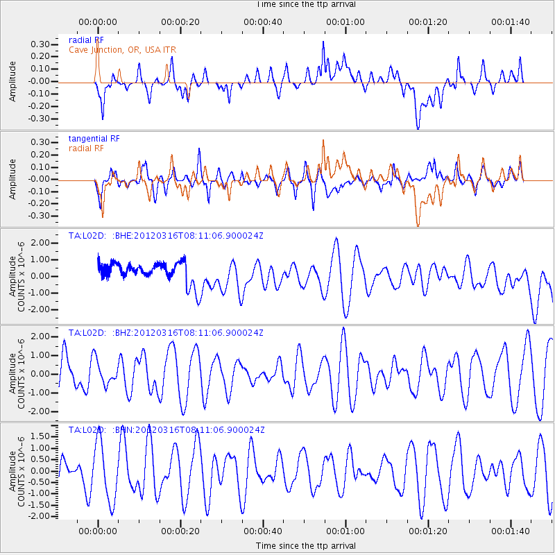
L02D Cave Junction, OR, USA - Earthquake Result Viewer
*The percent match for this event was below the threshold and hence no stack was calculated.
| Earthquake location: |
Leyte, Philippines |
| Earthquake latitude/longitude: |
10.0/125.6 |
| Earthquake time(UTC): |
2012/03/16 (076) 07:58:02 GMT |
| Earthquake Depth: |
18 km |
| Earthquake Magnitude: |
5.8 MB, 5.3 MS, 5.8 MW, 5.6 MW |
| Earthquake Catalog/Contributor: |
WHDF/NEIC |
|
| Network: |
TA USArray Transportable Network (new EarthScope stations) |
| Station: |
L02D Cave Junction, OR, USA |
| Lat/Lon: |
42.16 N/123.60 W |
| Elevation: |
458 m |
|
| Distance: |
98.3 deg |
| Az: |
44.632 deg |
| Baz: |
291.471 deg |
| Ray Param: |
$rayparam |
*The percent match for this event was below the threshold and hence was not used in the summary stack. |
|
| Radial Match: |
54.856323 % |
| Radial Bump: |
400 |
| Transverse Match: |
52.821373 % |
| Transverse Bump: |
400 |
| SOD ConfigId: |
440406 |
| Insert Time: |
2012-05-26 01:11:56.993 +0000 |
| GWidth: |
2.5 |
| Max Bumps: |
400 |
| Tol: |
0.001 |
|
Signal To Noise
| Channel | StoN | STA | LTA |
| TA:L02D: :BHZ:20120316T08:11:06.900024Z | 0.6243344 | 6.068636E-7 | 9.720169E-7 |
| TA:L02D: :BHN:20120316T08:11:06.900024Z | 2.7246594 | 1.3209673E-6 | 4.848192E-7 |
| TA:L02D: :BHE:20120316T08:11:06.900024Z | 1.6381375 | 1.0206328E-6 | 6.230447E-7 |
| Arrivals |
| Ps | |
| PpPs | |
| PsPs/PpSs | |


