You are here: Home > Network List > G - GEOSCOPE Stations List
> Station INU Inuyama, Japan > Earthquake Result Viewer
INU Inuyama, Japan - Earthquake Result Viewer
| Earthquake location: |
Tonga Islands |
| Earthquake latitude/longitude: |
-15.0/-175.6 |
| Earthquake time(UTC): |
1991/04/06 (096) 14:34:19 GMT |
| Earthquake Depth: |
14 km |
| Earthquake Magnitude: |
5.8 MB, 6.7 MS |
| Earthquake Catalog/Contributor: |
WHDF/NEIC |
|
| Network: |
G GEOSCOPE |
| Station: |
INU Inuyama, Japan |
| Lat/Lon: |
35.35 N/137.03 E |
| Elevation: |
132 m |
|
| Distance: |
67.3 deg |
| Az: |
319.286 deg |
| Baz: |
129.554 deg |
| Ray Param: |
0.05706155 |
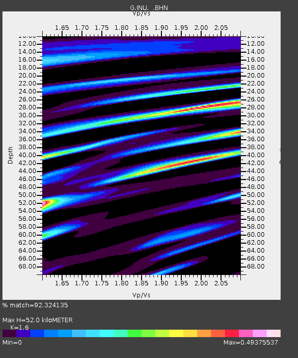
| Estimated Moho Depth: |
52.0 km |
| Estimated Crust Vp/Vs: |
1.60 |
| Assumed Crust Vp: |
6.461 km/s |
| Estimated Crust Vs: |
4.038 km/s |
| Estimated Crust Poisson's Ratio: |
0.18 |
|
| Radial Match: |
92.324135 % |
| Radial Bump: |
400 |
| Transverse Match: |
80.21186 % |
| Transverse Bump: |
400 |
| SOD ConfigId: |
16938 |
| Insert Time: |
2010-02-26 23:22:27.791 +0000 |
| GWidth: |
2.5 |
| Max Bumps: |
400 |
| Tol: |
0.001 |
|
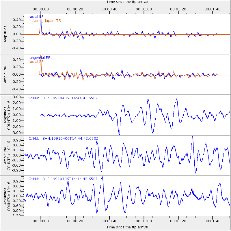
Signal To Noise
| Channel | StoN | STA | LTA |
| G:INU: :BHN:19910406T14:44:42.650Z | 1.3057086 | 1.8550615E-7 | 1.4207316E-7 |
| G:INU: :BHE:19910406T14:44:42.650Z | 1.703768 | 2.5308037E-7 | 1.4854157E-7 |
| G:INU: :BHZ:19910406T14:44:42.650Z | 3.4967983 | 4.1520883E-7 | 1.1873971E-7 |
| Arrivals |
| Ps | 5.0 SECOND |
| PpPs | 20 SECOND |
| PsPs/PpSs | 25 SECOND |


