You are here: Home > Network List > G - GEOSCOPE Stations List
> Station INU Inuyama, Japan > Earthquake Result Viewer
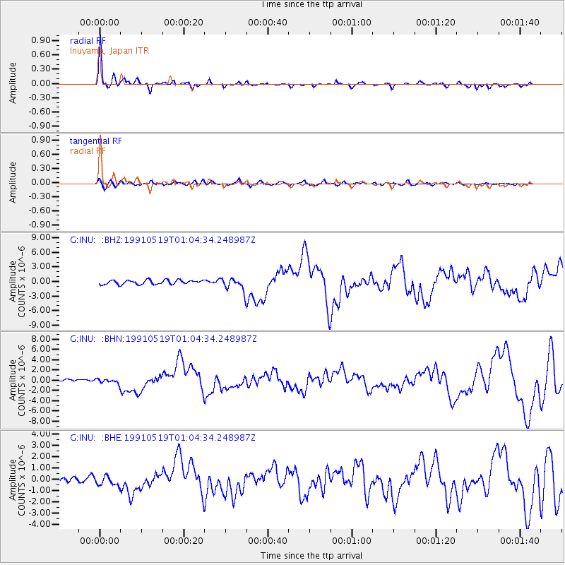
INU Inuyama, Japan - Earthquake Result Viewer

| Earthquake location: |
Minahassa Peninsula, Sulawesi |
| Earthquake latitude/longitude: |
1.1/122.9 |
| Earthquake time(UTC): |
1991/05/19 (139) 00:58:02 GMT |
| Earthquake Depth: |
33 km |
| Earthquake Magnitude: |
5.9 MB, 6.8 MS, 6.9 UNKNOWN |
| Earthquake Catalog/Contributor: |
WHDF/NEIC |
|
| Network: |
G GEOSCOPE |
| Station: |
INU Inuyama, Japan |
| Lat/Lon: |
35.35 N/137.03 E |
| Elevation: |
132 m |
|
| Distance: |
36.5 deg |
| Az: |
19.575 deg |
| Baz: |
204.191 deg |
| Ray Param: |
0.076561585 |
| Estimated Moho Depth: |
19.75 km |
| Estimated Crust Vp/Vs: |
2.04 |
| Assumed Crust Vp: |
6.461 km/s |
| Estimated Crust Vs: |
3.163 km/s |
| Estimated Crust Poisson's Ratio: |
0.34 |
|
| Radial Match: |
95.17279 % |
| Radial Bump: |
292 |
| Transverse Match: |
70.360374 % |
| Transverse Bump: |
400 |
| SOD ConfigId: |
16938 |
| Insert Time: |
2010-02-26 23:22:29.000 +0000 |
| GWidth: |
2.5 |
| Max Bumps: |
400 |
| Tol: |
0.001 |
|
Signal To Noise
| Channel | StoN | STA | LTA |
| G:INU: :BHN:19910519T01:04:34.248987Z | 1.6432956 | 4.6610992E-7 | 2.8364337E-7 |
| G:INU: :BHE:19910519T01:04:34.248987Z | 1.7401998 | 4.164311E-7 | 2.3930076E-7 |
| G:INU: :BHZ:19910519T01:04:34.248987Z | 3.3256955 | 1.4003114E-6 | 4.210582E-7 |
| Arrivals |
| Ps | 3.4 SECOND |
| PpPs | 8.7 SECOND |
| PsPs/PpSs | 12 SECOND |


