You are here: Home > Network List > G - GEOSCOPE Stations List
> Station INU Inuyama, Japan > Earthquake Result Viewer
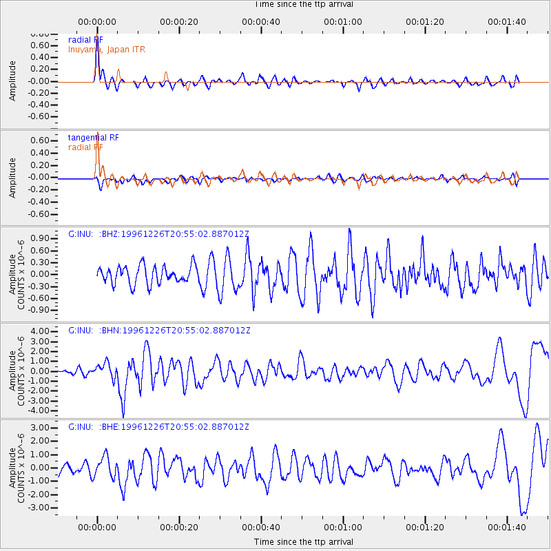
INU Inuyama, Japan - Earthquake Result Viewer
*The percent match for this event was below the threshold and hence no stack was calculated.
| Earthquake location: |
Irian Jaya, Indonesia |
| Earthquake latitude/longitude: |
-2.2/138.9 |
| Earthquake time(UTC): |
1996/12/26 (361) 20:48:23 GMT |
| Earthquake Depth: |
33 km |
| Earthquake Magnitude: |
6.0 MB, 6.1 MS, 6.3 UNKNOWN, 6.1 MW |
| Earthquake Catalog/Contributor: |
WHDF/NEIC |
|
| Network: |
G GEOSCOPE |
| Station: |
INU Inuyama, Japan |
| Lat/Lon: |
35.35 N/137.03 E |
| Elevation: |
132 m |
|
| Distance: |
37.4 deg |
| Az: |
357.432 deg |
| Baz: |
176.861 deg |
| Ray Param: |
$rayparam |
*The percent match for this event was below the threshold and hence was not used in the summary stack. |
|
| Radial Match: |
78.0145 % |
| Radial Bump: |
396 |
| Transverse Match: |
51.942486 % |
| Transverse Bump: |
400 |
| SOD ConfigId: |
4480 |
| Insert Time: |
2010-02-26 23:22:40.129 +0000 |
| GWidth: |
2.5 |
| Max Bumps: |
400 |
| Tol: |
0.001 |
|
Signal To Noise
| Channel | StoN | STA | LTA |
| G:INU: :BHN:19961226T20:55:02.887012Z | 3.0307322 | 7.674037E-7 | 2.5320736E-7 |
| G:INU: :BHE:19961226T20:55:02.887012Z | 2.1961467 | 7.804104E-7 | 3.553544E-7 |
| G:INU: :BHZ:19961226T20:55:02.887012Z | 2.015429 | 4.3741971E-7 | 2.1703552E-7 |
| Arrivals |
| Ps | |
| PpPs | |
| PsPs/PpSs | |


