You are here: Home > Network List > G - GEOSCOPE Stations List
> Station INU Inuyama, Japan > Earthquake Result Viewer
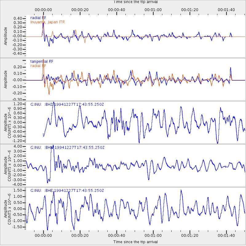
INU Inuyama, Japan - Earthquake Result Viewer
*The percent match for this event was below the threshold and hence no stack was calculated.
| Earthquake location: |
South Of Kermadec Islands |
| Earthquake latitude/longitude: |
-32.0/179.9 |
| Earthquake time(UTC): |
1994/12/27 (361) 17:32:52 GMT |
| Earthquake Depth: |
228 km |
| Earthquake Magnitude: |
6.0 MB, 6.1 UNKNOWN, 6.4 MW |
| Earthquake Catalog/Contributor: |
WHDF/NEIC |
|
| Network: |
G GEOSCOPE |
| Station: |
INU Inuyama, Japan |
| Lat/Lon: |
35.35 N/137.03 E |
| Elevation: |
132 m |
|
| Distance: |
78.1 deg |
| Az: |
325.389 deg |
| Baz: |
143.818 deg |
| Ray Param: |
$rayparam |
*The percent match for this event was below the threshold and hence was not used in the summary stack. |
|
| Radial Match: |
51.21066 % |
| Radial Bump: |
329 |
| Transverse Match: |
56.62567 % |
| Transverse Bump: |
400 |
| SOD ConfigId: |
4480 |
| Insert Time: |
2010-02-26 23:22:44.109 +0000 |
| GWidth: |
2.5 |
| Max Bumps: |
400 |
| Tol: |
0.001 |
|
Signal To Noise
| Channel | StoN | STA | LTA |
| G:INU: :BHN:19941227T17:43:55.250Z | 3.7614205 | 2.3034406E-6 | 6.123858E-7 |
| G:INU: :BHE:19941227T17:43:55.250Z | 1.3674006 | 8.0932926E-7 | 5.9187425E-7 |
| G:INU: :BHZ:19941227T17:43:55.250Z | 0.6412994 | 3.3703304E-7 | 5.255471E-7 |
| Arrivals |
| Ps | |
| PpPs | |
| PsPs/PpSs | |


