You are here: Home > Network List > TA - USArray Transportable Network (new EarthScope stations) Stations List
> Station TOLK Tollok Lake Research Station, AK, USA > Earthquake Result Viewer
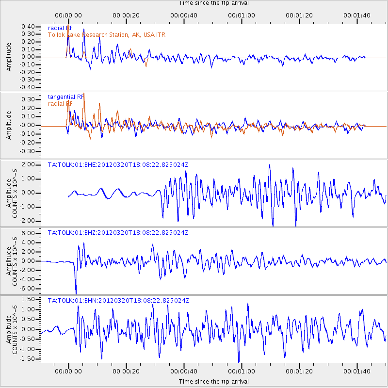
TOLK Tollok Lake Research Station, AK, USA - Earthquake Result Viewer
*The percent match for this event was below the threshold and hence no stack was calculated.
| Earthquake location: |
Irian Jaya, Indonesia |
| Earthquake latitude/longitude: |
-3.8/140.3 |
| Earthquake time(UTC): |
2012/03/20 (080) 17:56:18 GMT |
| Earthquake Depth: |
66 km |
| Earthquake Magnitude: |
6.2 MB, 6.1 MW, 6.2 MW |
| Earthquake Catalog/Contributor: |
WHDF/NEIC |
|
| Network: |
TA USArray Transportable Network (new EarthScope stations) |
| Station: |
TOLK Tollok Lake Research Station, AK, USA |
| Lat/Lon: |
68.64 N/149.57 W |
| Elevation: |
760 m |
|
| Distance: |
86.4 deg |
| Az: |
20.199 deg |
| Baz: |
250.126 deg |
| Ray Param: |
$rayparam |
*The percent match for this event was below the threshold and hence was not used in the summary stack. |
|
| Radial Match: |
85.07435 % |
| Radial Bump: |
400 |
| Transverse Match: |
71.274895 % |
| Transverse Bump: |
400 |
| SOD ConfigId: |
440406 |
| Insert Time: |
2012-06-03 02:23:12.339 +0000 |
| GWidth: |
2.5 |
| Max Bumps: |
400 |
| Tol: |
0.001 |
|
Signal To Noise
| Channel | StoN | STA | LTA |
| TA:TOLK:01:BHZ:20120320T18:08:22.825024Z | 11.881693 | 2.1753538E-6 | 1.830845E-7 |
| TA:TOLK:01:BHN:20120320T18:08:22.825024Z | 2.0130823 | 4.8976534E-7 | 2.4329128E-7 |
| TA:TOLK:01:BHE:20120320T18:08:22.825024Z | 3.422576 | 5.847856E-7 | 1.7086124E-7 |
| Arrivals |
| Ps | |
| PpPs | |
| PsPs/PpSs | |


