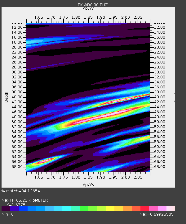
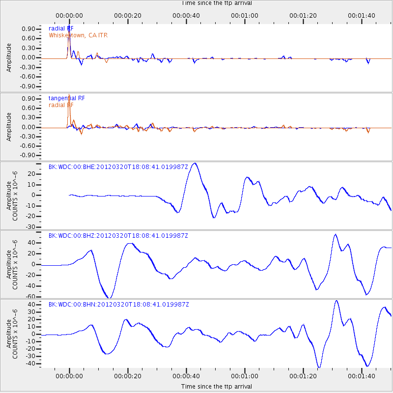
WDC Whiskeytown, CA - Earthquake Result Viewer

Earthquake location: Near Coast Of Guerrero, Mexico
Earthquake latitude/longitude: 16.5/-98.2
Earthquake time(UTC): 2012/03/20 (080) 18:02:47 GMT
Earthquake Depth: 20 km
Earthquake Magnitude: 6.6 MB, 7.6 MS, 7.4 MW, 7.4 MW
Earthquake Catalog/Contributor: WHDF/NEIC
Network: BK Berkeley Digital Seismograph Network
Station: WDC Whiskeytown, CA
Lat/Lon: 40.58 N/122.54 W
Elevation: 268 m
Distance: 31.9 deg
Az: 323.633 deg
Baz: 131.68 deg
Ray Param: 0.07885029
Estimated Moho Depth: 65.25 km
Estimated Crust Vp/Vs: 1.68
Assumed Crust Vp: 6.566 km/s
Estimated Crust Vs: 3.914 km/s
Estimated Crust Poisson's Ratio: 0.22
Radial Match: 94.12654 %
Radial Bump: 279
Transverse Match: 69.041985 %
Transverse Bump: 400
SOD ConfigId: 440406
Insert Time: 2012-06-03 02:27:43.281 +0000
GWidth: 2.5
Max Bumps: 400
Tol: 0.001

Signal To Noise

ChannelStoNSTALTA
BK:WDC:00:BHZ:20120320T18:08:41.019987Z34.959348.457228E-62.4191613E-7
BK:WDC:00:BHN:20120320T18:08:41.019987Z8.34065153.733779E-64.4766037E-7
BK:WDC:00:BHE:20120320T18:08:41.019987Z12.2370074.63811E-63.7902322E-7
Arrivals
Ps7.4 SECOND
PpPs24 SECOND
PsPs/PpSs32 SECOND