WHY Whitehorse, YT - Earthquake Result Viewer
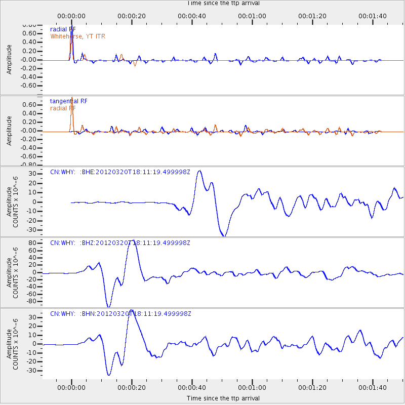
Earthquake location: Near Coast Of Guerrero, Mexico
Earthquake latitude/longitude: 16.5/-98.2
Earthquake time(UTC): 2012/03/20 (080) 18:02:47 GMT
Earthquake Depth: 20 km
Earthquake Magnitude: 6.6 MB, 7.6 MS, 7.4 MW, 7.4 MW
Earthquake Catalog/Contributor: WHDF/NEIC
Network: CN Canadian National Seismograph Network
Station: WHY Whitehorse, YT
Lat/Lon: 60.66 N/134.88 W
Elevation: 1292 m
Distance: 51.3 deg
Az: 337.886 deg
Baz: 132.834 deg
Ray Param: 0.06744903
Estimated Moho Depth: 36.75 km
Estimated Crust Vp/Vs: 1.78
Assumed Crust Vp: 6.419 km/s
Estimated Crust Vs: 3.601 km/s
Estimated Crust Poisson's Ratio: 0.27
Radial Match: 98.64156 %
Radial Bump: 247
Transverse Match: 90.164665 %
Transverse Bump: 400
SOD ConfigId: 440406
Insert Time: 2012-06-03 02:28:39.308 +0000
GWidth: 2.5
Max Bumps: 400
Tol: 0.001

Signal To Noise

ChannelStoNSTALTA
CN:WHY: :BHZ:20120320T18:11:19.499998Z10.7458244.7935355E-64.4608356E-7
CN:WHY: :BHN:20120320T18:11:19.499998Z5.54726081.7498501E-63.1544397E-7
CN:WHY: :BHE:20120320T18:11:19.499998Z4.20489361.6627258E-63.9542638E-7
Arrivals
Ps4.7 SECOND
PpPs15 SECOND
PsPs/PpSs20 SECOND