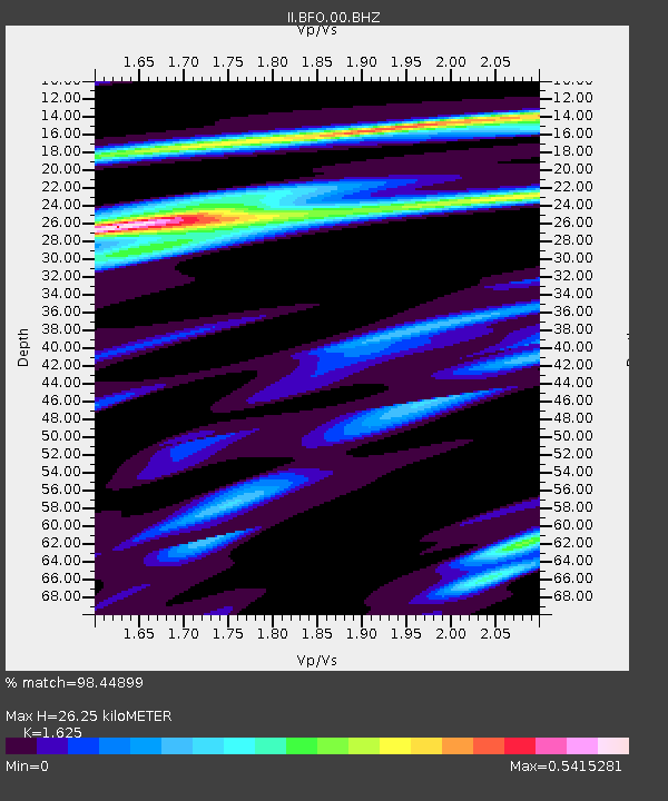
BFO Black Forest Observatory, Schiltach, Germany - Earthquake Result Viewer

Earthquake location: Near Coast Of Guerrero, Mexico
Earthquake latitude/longitude: 16.5/-98.2
Earthquake time(UTC): 2012/03/20 (080) 18:02:47 GMT
Earthquake Depth: 20 km
Earthquake Magnitude: 6.6 MB, 7.6 MS, 7.4 MW, 7.4 MW
Earthquake Catalog/Contributor: WHDF/NEIC
Network: II Global Seismograph Network (GSN - IRIS/IDA)
Station: BFO Black Forest Observatory, Schiltach, Germany
Lat/Lon: 48.33 N/8.33 E
Elevation: 589 m
Distance: 88.4 deg
Az: 39.782 deg
Baz: 293.086 deg
Ray Param: 0.04258622
Estimated Moho Depth: 26.25 km
Estimated Crust Vp/Vs: 1.62
Assumed Crust Vp: 6.264 km/s
Estimated Crust Vs: 3.855 km/s
Estimated Crust Poisson's Ratio: 0.20
Radial Match: 98.44899 %
Radial Bump: 351
Transverse Match: 90.179436 %
Transverse Bump: 400
SOD ConfigId: 440406
Insert Time: 2012-06-03 02:30:41.491 +0000
GWidth: 2.5
Max Bumps: 400
Tol: 0.001

Signal To Noise

ChannelStoNSTALTA
II:BFO:00:BHZ:20120320T18:15:06.533018Z22.9835644.0058458E-61.7429176E-7
II:BFO:00:BHN:20120320T18:15:06.533018Z1.82608433.6394496E-71.993035E-7
II:BFO:00:BHE:20120320T18:15:06.533018Z5.65425351.068889E-61.8904157E-7
Arrivals
Ps2.7 SECOND
PpPs11 SECOND
PsPs/PpSs13 SECOND