You are here: Home > Network List > IW - Intermountain West Stations List
> Station PLID Pearl Lake, Idaho, USA > Earthquake Result Viewer
PLID Pearl Lake, Idaho, USA - Earthquake Result Viewer
| Earthquake location: |
Near Coast Of Guerrero, Mexico |
| Earthquake latitude/longitude: |
16.5/-98.2 |
| Earthquake time(UTC): |
2012/03/20 (080) 18:02:47 GMT |
| Earthquake Depth: |
20 km |
| Earthquake Magnitude: |
6.6 MB, 7.6 MS, 7.4 MW, 7.4 MW |
| Earthquake Catalog/Contributor: |
WHDF/NEIC |
|
| Network: |
IW Intermountain West |
| Station: |
PLID Pearl Lake, Idaho, USA |
| Lat/Lon: |
45.09 N/116.00 W |
| Elevation: |
2164 m |
|
| Distance: |
32.2 deg |
| Az: |
336.053 deg |
| Baz: |
146.655 deg |
| Ray Param: |
0.07873991 |
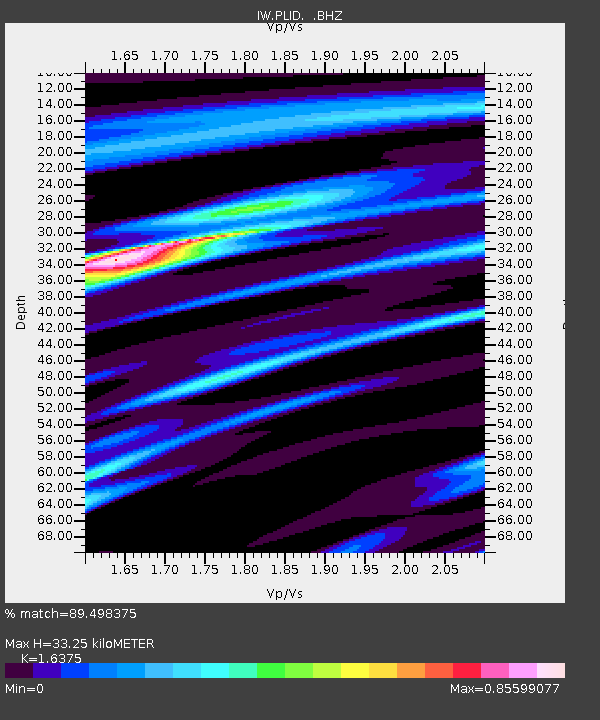
| Estimated Moho Depth: |
33.25 km |
| Estimated Crust Vp/Vs: |
1.64 |
| Assumed Crust Vp: |
6.571 km/s |
| Estimated Crust Vs: |
4.013 km/s |
| Estimated Crust Poisson's Ratio: |
0.20 |
|
| Radial Match: |
89.498375 % |
| Radial Bump: |
274 |
| Transverse Match: |
85.71867 % |
| Transverse Bump: |
400 |
| SOD ConfigId: |
440406 |
| Insert Time: |
2012-06-03 02:31:12.574 +0000 |
| GWidth: |
2.5 |
| Max Bumps: |
400 |
| Tol: |
0.001 |
|
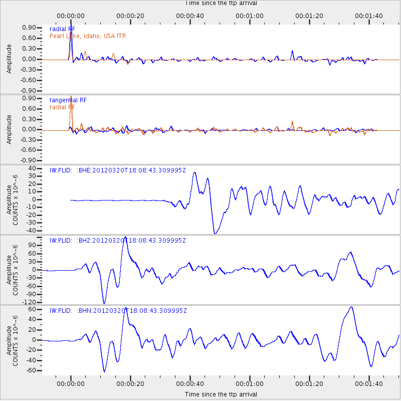
Signal To Noise
| Channel | StoN | STA | LTA |
| IW:PLID: :BHZ:20120320T18:08:43.309995Z | 18.77877 | 8.634955E-6 | 4.5982534E-7 |
| IW:PLID: :BHN:20120320T18:08:43.309995Z | 15.979544 | 4.497068E-6 | 2.8142657E-7 |
| IW:PLID: :BHE:20120320T18:08:43.309995Z | 14.638761 | 2.56311E-6 | 1.7509065E-7 |
| Arrivals |
| Ps | 3.5 SECOND |
| PpPs | 12 SECOND |
| PsPs/PpSs | 16 SECOND |


