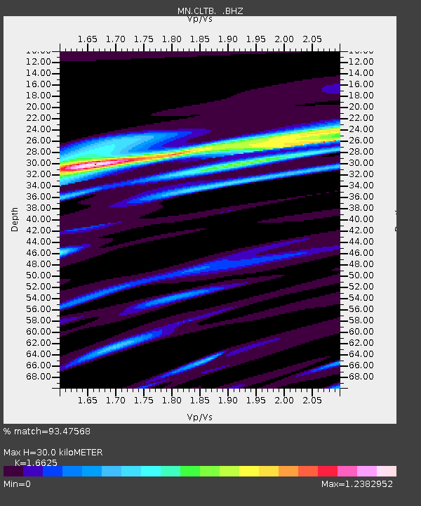
CLTB Caltabellotta, Italy - Earthquake Result Viewer
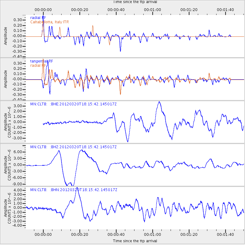
Earthquake location: Near Coast Of Guerrero, Mexico
Earthquake latitude/longitude: 16.5/-98.2
Earthquake time(UTC): 2012/03/20 (080) 18:02:47 GMT
Earthquake Depth: 20 km
Earthquake Magnitude: 6.6 MB, 7.6 MS, 7.4 MW, 7.4 MW
Earthquake Catalog/Contributor: WHDF/NEIC
Network: MN MEDNET Project
Station: CLTB Caltabellotta, Italy
Lat/Lon: 37.58 N/13.22 E
Elevation: 949 m
Distance: 96.2 deg
Az: 48.055 deg
Baz: 296.087 deg
Ray Param: 0.040583987
Estimated Moho Depth: 30.0 km
Estimated Crust Vp/Vs: 1.66
Assumed Crust Vp: 5.657 km/s
Estimated Crust Vs: 3.403 km/s
Estimated Crust Poisson's Ratio: 0.22
Radial Match: 93.47568 %
Radial Bump: 400
Transverse Match: 88.86391 %
Transverse Bump: 400
SOD ConfigId: 440406
Insert Time: 2012-06-03 02:32:13.679 +0000
GWidth: 2.5
Max Bumps: 400
Tol: 0.001

Signal To Noise

ChannelStoNSTALTA
MN:CLTB: :BHZ:20120320T18:15:42.145017Z9.1689617.2712504E-77.930289E-8
MN:CLTB: :BHN:20120320T18:15:42.145017Z0.90495471.4490786E-71.601272E-7
MN:CLTB: :BHE:20120320T18:15:42.145017Z0.99558941.5924115E-71.5994661E-7
Arrivals
Ps3.6 SECOND
PpPs14 SECOND
PsPs/PpSs17 SECOND