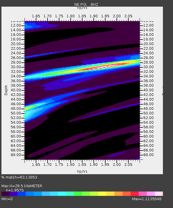
PQI Presque Isle, ME - Earthquake Result Viewer
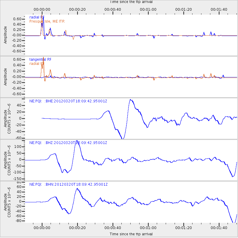
Earthquake location: Near Coast Of Guerrero, Mexico
Earthquake latitude/longitude: 16.5/-98.2
Earthquake time(UTC): 2012/03/20 (080) 18:02:47 GMT
Earthquake Depth: 20 km
Earthquake Magnitude: 6.6 MB, 7.6 MS, 7.4 MW, 7.4 MW
Earthquake Catalog/Contributor: WHDF/NEIC
Network: NE New England Seismic Network
Station: PQI Presque Isle, ME
Lat/Lon: 46.67 N/68.01 W
Elevation: 175 m
Distance: 39.2 deg
Az: 33.293 deg
Baz: 229.883 deg
Ray Param: 0.075124174
Estimated Moho Depth: 29.5 km
Estimated Crust Vp/Vs: 1.96
Assumed Crust Vp: 6.419 km/s
Estimated Crust Vs: 3.279 km/s
Estimated Crust Poisson's Ratio: 0.32
Radial Match: 93.13853 %
Radial Bump: 180
Transverse Match: 71.00225 %
Transverse Bump: 400
SOD ConfigId: 440406
Insert Time: 2012-06-03 02:33:02.288 +0000
GWidth: 2.5
Max Bumps: 400
Tol: 0.001

Signal To Noise

ChannelStoNSTALTA
NE:PQI: :BHZ:20120320T18:09:42.95001Z20.7067811.3865899E-56.696308E-7
NE:PQI: :BHN:20120320T18:09:42.95001Z8.2873614.7591584E-65.7426706E-7
NE:PQI: :BHE:20120320T18:09:42.95001Z6.5679535.4040847E-68.2279587E-7
Arrivals
Ps4.7 SECOND
PpPs13 SECOND
PsPs/PpSs17 SECOND