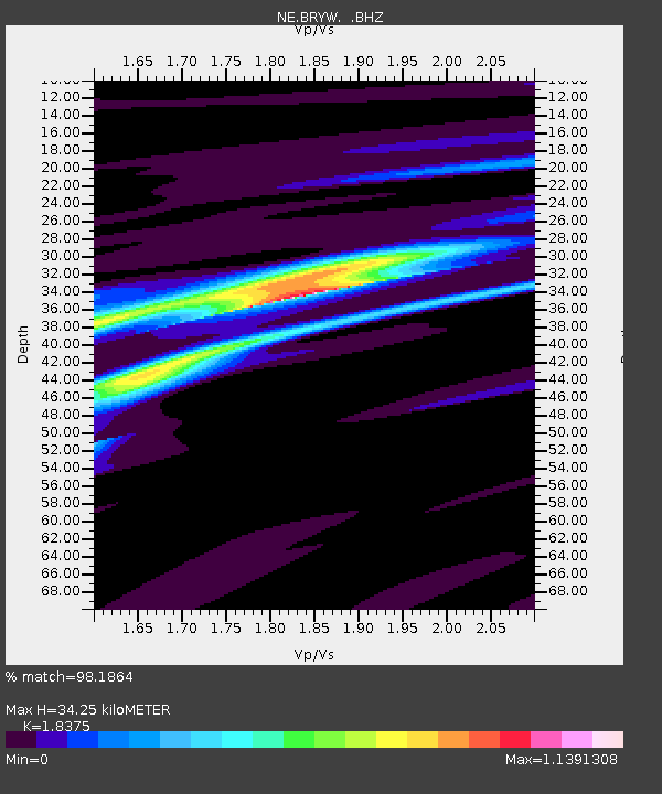
BRYW Smithfield, RI - Earthquake Result Viewer

Earthquake location: Near Coast Of Guerrero, Mexico
Earthquake latitude/longitude: 16.5/-98.2
Earthquake time(UTC): 2012/03/20 (080) 18:02:47 GMT
Earthquake Depth: 20 km
Earthquake Magnitude: 6.6 MB, 7.6 MS, 7.4 MW, 7.4 MW
Earthquake Catalog/Contributor: WHDF/NEIC
Network: NE New England Seismic Network
Station: BRYW Smithfield, RI
Lat/Lon: 41.92 N/71.54 W
Elevation: 107 m
Distance: 34.2 deg
Az: 36.664 deg
Baz: 230.135 deg
Ray Param: 0.07785508
Estimated Moho Depth: 34.25 km
Estimated Crust Vp/Vs: 1.84
Assumed Crust Vp: 6.472 km/s
Estimated Crust Vs: 3.522 km/s
Estimated Crust Poisson's Ratio: 0.29
Radial Match: 98.1864 %
Radial Bump: 247
Transverse Match: 93.83735 %
Transverse Bump: 400
SOD ConfigId: 440406
Insert Time: 2012-06-03 02:33:15.356 +0000
GWidth: 2.5
Max Bumps: 400
Tol: 0.001

Signal To Noise

ChannelStoNSTALTA
NE:BRYW: :BHZ:20120320T18:09:00.485013Z60.8574831.5735106E-52.5855664E-7
NE:BRYW: :BHN:20120320T18:09:00.485013Z16.8278275.3246945E-63.16422E-7
NE:BRYW: :BHE:20120320T18:09:00.485013Z27.7769668.569959E-63.0852755E-7
Arrivals
Ps4.8 SECOND
PpPs14 SECOND
PsPs/PpSs19 SECOND