You are here: Home > Network List > G - GEOSCOPE Stations List
> Station INU Inuyama, Japan > Earthquake Result Viewer
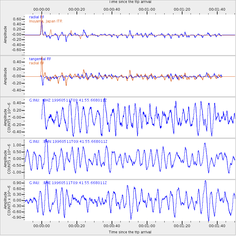
INU Inuyama, Japan - Earthquake Result Viewer
*The percent match for this event was below the threshold and hence no stack was calculated.
| Earthquake location: |
Irian Jaya Region, Indonesia |
| Earthquake latitude/longitude: |
-3.3/135.9 |
| Earthquake time(UTC): |
1996/05/11 (132) 09:35:06 GMT |
| Earthquake Depth: |
24 km |
| Earthquake Magnitude: |
5.7 MS, 5.4 MB, 5.9 UNKNOWN, 5.8 MW |
| Earthquake Catalog/Contributor: |
WHDF/NEIC |
|
| Network: |
G GEOSCOPE |
| Station: |
INU Inuyama, Japan |
| Lat/Lon: |
35.35 N/137.03 E |
| Elevation: |
132 m |
|
| Distance: |
38.5 deg |
| Az: |
1.541 deg |
| Baz: |
181.882 deg |
| Ray Param: |
$rayparam |
*The percent match for this event was below the threshold and hence was not used in the summary stack. |
|
| Radial Match: |
70.95982 % |
| Radial Bump: |
307 |
| Transverse Match: |
63.522705 % |
| Transverse Bump: |
400 |
| SOD ConfigId: |
4480 |
| Insert Time: |
2010-02-26 23:23:06.847 +0000 |
| GWidth: |
2.5 |
| Max Bumps: |
400 |
| Tol: |
0.001 |
|
Signal To Noise
| Channel | StoN | STA | LTA |
| G:INU: :BHN:19960511T09:41:55.668011Z | 2.389088 | 8.231839E-7 | 3.445599E-7 |
| G:INU: :BHE:19960511T09:41:55.668011Z | 2.6773686 | 5.872772E-7 | 2.1934865E-7 |
| G:INU: :BHZ:19960511T09:41:55.668011Z | 0.9637681 | 2.3425902E-7 | 2.4306576E-7 |
| Arrivals |
| Ps | |
| PpPs | |
| PsPs/PpSs | |


