You are here: Home > Network List > TA - USArray Transportable Network (new EarthScope stations) Stations List
> Station G05D Wamic, OR, USA > Earthquake Result Viewer
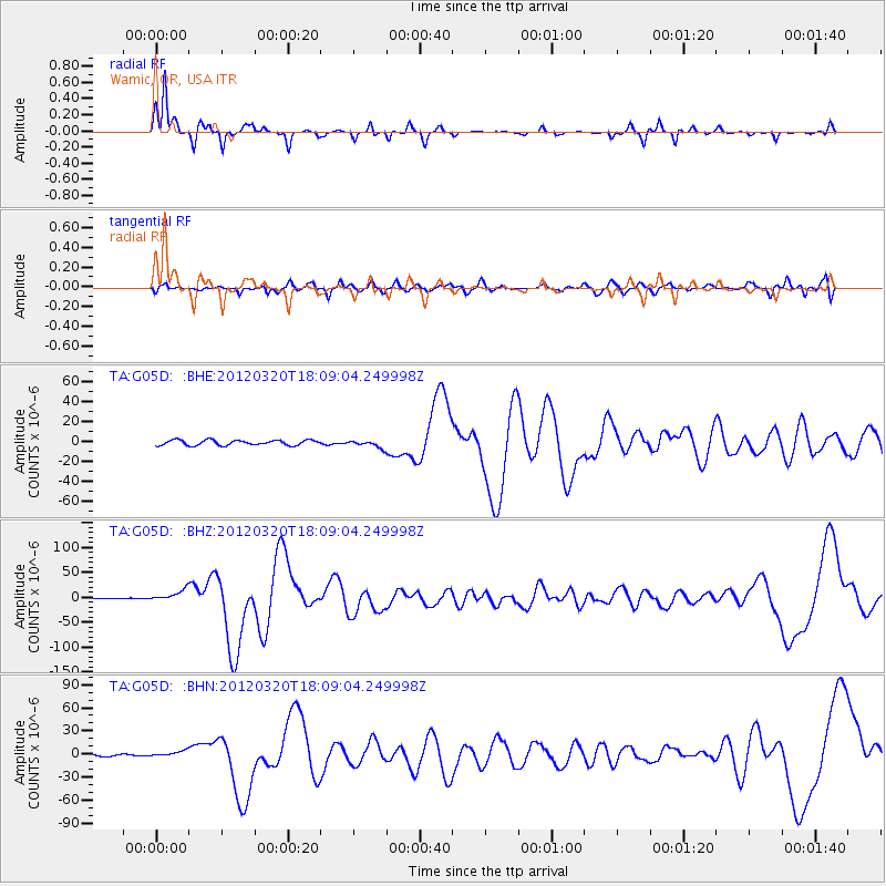
G05D Wamic, OR, USA - Earthquake Result Viewer
*The percent match for this event was below the threshold and hence no stack was calculated.
| Earthquake location: |
Near Coast Of Guerrero, Mexico |
| Earthquake latitude/longitude: |
16.5/-98.2 |
| Earthquake time(UTC): |
2012/03/20 (080) 18:02:47 GMT |
| Earthquake Depth: |
20 km |
| Earthquake Magnitude: |
6.6 MB, 7.6 MS, 7.4 MW, 7.4 MW |
| Earthquake Catalog/Contributor: |
WHDF/NEIC |
|
| Network: |
TA USArray Transportable Network (new EarthScope stations) |
| Station: |
G05D Wamic, OR, USA |
| Lat/Lon: |
45.24 N/121.32 W |
| Elevation: |
592 m |
|
| Distance: |
34.6 deg |
| Az: |
330.796 deg |
| Baz: |
138.505 deg |
| Ray Param: |
$rayparam |
*The percent match for this event was below the threshold and hence was not used in the summary stack. |
|
| Radial Match: |
87.72281 % |
| Radial Bump: |
223 |
| Transverse Match: |
66.74859 % |
| Transverse Bump: |
400 |
| SOD ConfigId: |
440406 |
| Insert Time: |
2012-06-03 02:35:11.775 +0000 |
| GWidth: |
2.5 |
| Max Bumps: |
400 |
| Tol: |
0.001 |
|
Signal To Noise
| Channel | StoN | STA | LTA |
| TA:G05D: :BHZ:20120320T18:09:04.249998Z | 12.127881 | 1.12764155E-5 | 9.297928E-7 |
| TA:G05D: :BHN:20120320T18:09:04.249998Z | 2.5968165 | 4.048804E-6 | 1.5591413E-6 |
| TA:G05D: :BHE:20120320T18:09:04.249998Z | 1.4465059 | 3.6822312E-6 | 2.545604E-6 |
| Arrivals |
| Ps | |
| PpPs | |
| PsPs/PpSs | |


