You are here: Home > Network List > G - GEOSCOPE Stations List
> Station INU Inuyama, Japan > Earthquake Result Viewer
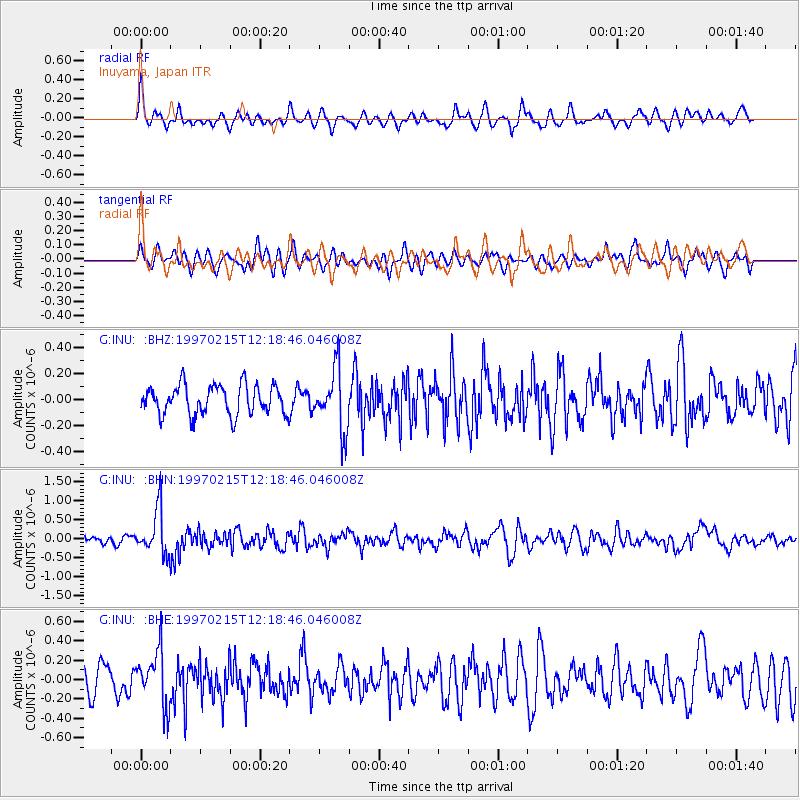
INU Inuyama, Japan - Earthquake Result Viewer
*The percent match for this event was below the threshold and hence no stack was calculated.
| Earthquake location: |
Bali Sea |
| Earthquake latitude/longitude: |
-7.8/117.4 |
| Earthquake time(UTC): |
1997/02/15 (046) 12:11:14 GMT |
| Earthquake Depth: |
274 km |
| Earthquake Magnitude: |
5.6 MB, 5.6 UNKNOWN, 5.6 MW |
| Earthquake Catalog/Contributor: |
WHDF/NEIC |
|
| Network: |
G GEOSCOPE |
| Station: |
INU Inuyama, Japan |
| Lat/Lon: |
35.35 N/137.03 E |
| Elevation: |
132 m |
|
| Distance: |
46.7 deg |
| Az: |
22.145 deg |
| Baz: |
207.189 deg |
| Ray Param: |
$rayparam |
*The percent match for this event was below the threshold and hence was not used in the summary stack. |
|
| Radial Match: |
65.90782 % |
| Radial Bump: |
400 |
| Transverse Match: |
50.883316 % |
| Transverse Bump: |
400 |
| SOD ConfigId: |
4480 |
| Insert Time: |
2010-02-26 23:23:10.940 +0000 |
| GWidth: |
2.5 |
| Max Bumps: |
400 |
| Tol: |
0.001 |
|
Signal To Noise
| Channel | StoN | STA | LTA |
| G:INU: :BHN:19970215T12:18:46.046008Z | 5.4939194 | 5.9142843E-7 | 1.0765145E-7 |
| G:INU: :BHE:19970215T12:18:46.046008Z | 1.7562411 | 2.8442508E-7 | 1.6195105E-7 |
| G:INU: :BHZ:19970215T12:18:46.046008Z | 2.0893886 | 2.3613003E-7 | 1.1301395E-7 |
| Arrivals |
| Ps | |
| PpPs | |
| PsPs/PpSs | |


