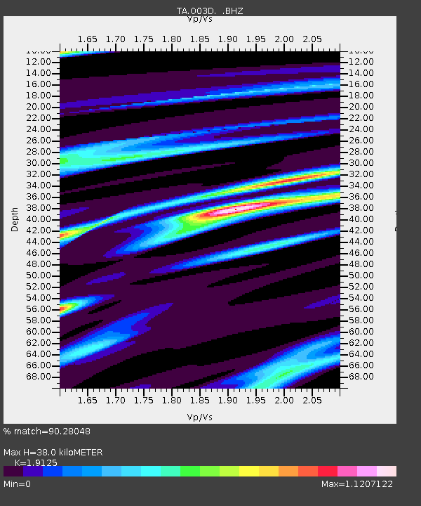
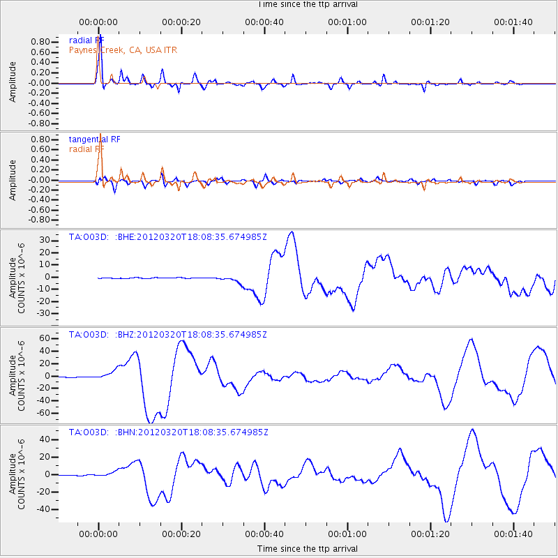
O03D Paynes Creek, CA, USA - Earthquake Result Viewer

Earthquake location: Near Coast Of Guerrero, Mexico
Earthquake latitude/longitude: 16.5/-98.2
Earthquake time(UTC): 2012/03/20 (080) 18:02:47 GMT
Earthquake Depth: 20 km
Earthquake Magnitude: 6.6 MB, 7.6 MS, 7.4 MW, 7.4 MW
Earthquake Catalog/Contributor: WHDF/NEIC
Network: TA USArray Transportable Network (new EarthScope stations)
Station: O03D Paynes Creek, CA, USA
Lat/Lon: 40.29 N/121.80 W
Elevation: 968 m
Distance: 31.3 deg
Az: 323.951 deg
Baz: 132.428 deg
Ray Param: 0.07908946
Estimated Moho Depth: 38.0 km
Estimated Crust Vp/Vs: 1.91
Assumed Crust Vp: 6.566 km/s
Estimated Crust Vs: 3.433 km/s
Estimated Crust Poisson's Ratio: 0.31
Radial Match: 90.28048 %
Radial Bump: 400
Transverse Match: 77.553856 %
Transverse Bump: 400
SOD ConfigId: 440406
Insert Time: 2012-06-03 02:36:07.573 +0000
GWidth: 2.5
Max Bumps: 400
Tol: 0.001

Signal To Noise

ChannelStoNSTALTA
TA:O03D: :BHZ:20120320T18:08:35.674985Z36.8763588.04316E-62.1811157E-7
TA:O03D: :BHN:20120320T18:08:35.674985Z13.9628262.9907983E-62.1419721E-7
TA:O03D: :BHE:20120320T18:08:35.674985Z9.4466652.9072517E-63.0775428E-7
Arrivals
Ps5.7 SECOND
PpPs16 SECOND
PsPs/PpSs21 SECOND