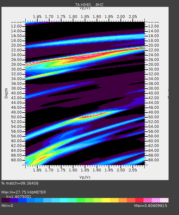
H04D Lebanon, OR, USA - Earthquake Result Viewer
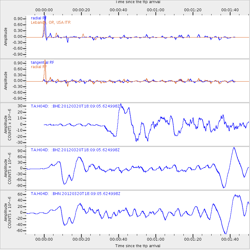
Earthquake location: Near Coast Of Guerrero, Mexico
Earthquake latitude/longitude: 16.5/-98.2
Earthquake time(UTC): 2012/03/20 (080) 18:02:47 GMT
Earthquake Depth: 20 km
Earthquake Magnitude: 6.6 MB, 7.6 MS, 7.4 MW, 7.4 MW
Earthquake Catalog/Contributor: WHDF/NEIC
Network: TA USArray Transportable Network (new EarthScope stations)
Station: H04D Lebanon, OR, USA
Lat/Lon: 44.52 N/122.74 W
Elevation: 284 m
Distance: 34.8 deg
Az: 328.635 deg
Baz: 135.728 deg
Ray Param: 0.077554174
Estimated Moho Depth: 27.75 km
Estimated Crust Vp/Vs: 1.61
Assumed Crust Vp: 6.566 km/s
Estimated Crust Vs: 4.085 km/s
Estimated Crust Poisson's Ratio: 0.18
Radial Match: 89.36406 %
Radial Bump: 234
Transverse Match: 68.737816 %
Transverse Bump: 400
SOD ConfigId: 440406
Insert Time: 2012-06-03 02:36:51.596 +0000
GWidth: 2.5
Max Bumps: 400
Tol: 0.001

Signal To Noise

ChannelStoNSTALTA
TA:H04D: :BHZ:20120320T18:09:05.624998Z11.1190841.2084819E-51.0868538E-6
TA:H04D: :BHN:20120320T18:09:05.624998Z7.24599466.43519E-68.8810305E-7
TA:H04D: :BHE:20120320T18:09:05.624998Z4.567914.9936416E-61.0932005E-6
Arrivals
Ps2.8 SECOND
PpPs10 SECOND
PsPs/PpSs13 SECOND