You are here: Home > Network List > TA - USArray Transportable Network (new EarthScope stations) Stations List
> Station C31A Landman Farms, Northwood, ND, USA > Earthquake Result Viewer
C31A Landman Farms, Northwood, ND, USA - Earthquake Result Viewer
| Earthquake location: |
Near Coast Of Guerrero, Mexico |
| Earthquake latitude/longitude: |
16.5/-98.2 |
| Earthquake time(UTC): |
2012/03/20 (080) 18:02:47 GMT |
| Earthquake Depth: |
20 km |
| Earthquake Magnitude: |
6.6 MB, 7.6 MS, 7.4 MW, 7.4 MW |
| Earthquake Catalog/Contributor: |
WHDF/NEIC |
|
| Network: |
TA USArray Transportable Network (new EarthScope stations) |
| Station: |
C31A Landman Farms, Northwood, ND, USA |
| Lat/Lon: |
47.79 N/97.73 W |
| Elevation: |
384 m |
|
| Distance: |
31.2 deg |
| Az: |
0.647 deg |
| Baz: |
180.921 deg |
| Ray Param: |
0.07911559 |
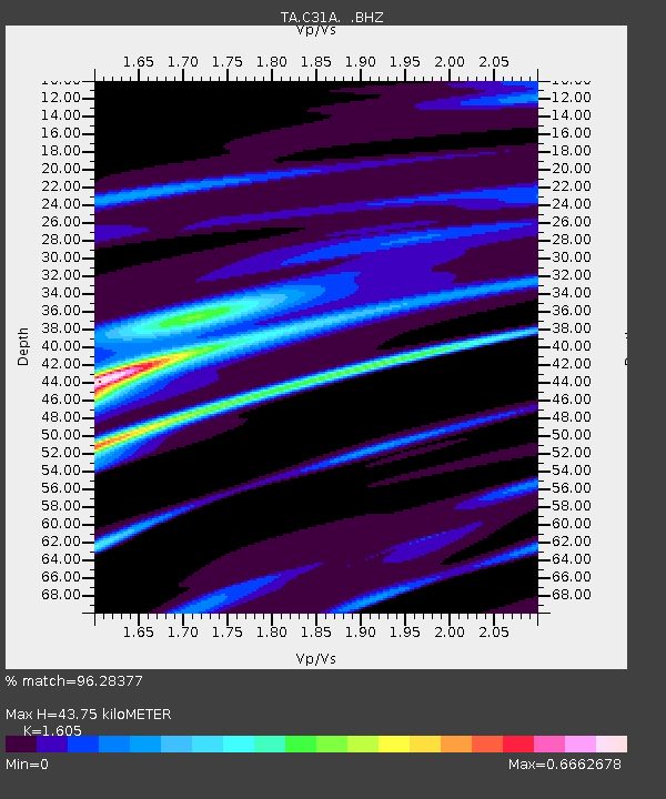
| Estimated Moho Depth: |
43.75 km |
| Estimated Crust Vp/Vs: |
1.61 |
| Assumed Crust Vp: |
6.498 km/s |
| Estimated Crust Vs: |
4.048 km/s |
| Estimated Crust Poisson's Ratio: |
0.18 |
|
| Radial Match: |
96.28377 % |
| Radial Bump: |
246 |
| Transverse Match: |
80.47551 % |
| Transverse Bump: |
400 |
| SOD ConfigId: |
440406 |
| Insert Time: |
2012-06-03 02:37:56.210 +0000 |
| GWidth: |
2.5 |
| Max Bumps: |
400 |
| Tol: |
0.001 |
|

Signal To Noise
| Channel | StoN | STA | LTA |
| TA:C31A: :BHZ:20120320T18:08:34.799985Z | 83.23828 | 2.041281E-5 | 2.4523345E-7 |
| TA:C31A: :BHN:20120320T18:08:34.799985Z | 42.238106 | 1.5536709E-5 | 3.678363E-7 |
| TA:C31A: :BHE:20120320T18:08:34.799985Z | 3.8577006 | 6.0255195E-7 | 1.5619459E-7 |
| Arrivals |
| Ps | 4.5 SECOND |
| PpPs | 16 SECOND |
| PsPs/PpSs | 20 SECOND |


