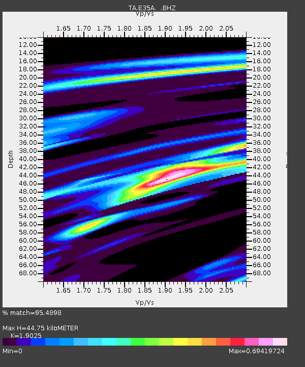
E35A Pequot Lakes, MN, USA - Earthquake Result Viewer
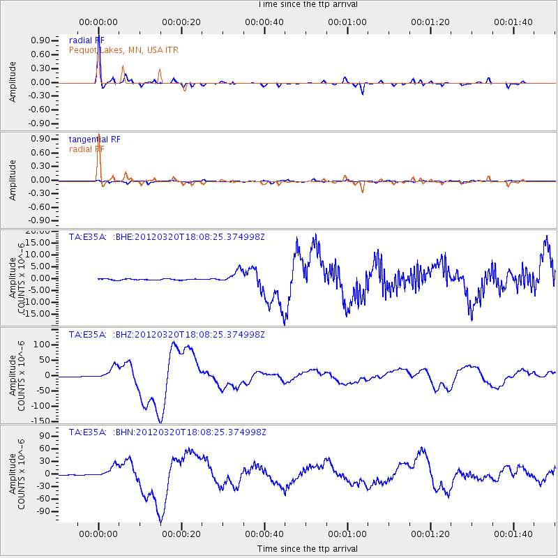
Earthquake location: Near Coast Of Guerrero, Mexico
Earthquake latitude/longitude: 16.5/-98.2
Earthquake time(UTC): 2012/03/20 (080) 18:02:47 GMT
Earthquake Depth: 20 km
Earthquake Magnitude: 6.6 MB, 7.6 MS, 7.4 MW, 7.4 MW
Earthquake Catalog/Contributor: WHDF/NEIC
Network: TA USArray Transportable Network (new EarthScope stations)
Station: E35A Pequot Lakes, MN, USA
Lat/Lon: 46.56 N/94.40 W
Elevation: 409 m
Distance: 30.1 deg
Az: 5.262 deg
Baz: 187.325 deg
Ray Param: 0.079396635
Estimated Moho Depth: 44.75 km
Estimated Crust Vp/Vs: 1.90
Assumed Crust Vp: 6.419 km/s
Estimated Crust Vs: 3.374 km/s
Estimated Crust Poisson's Ratio: 0.31
Radial Match: 95.4898 %
Radial Bump: 228
Transverse Match: 85.17824 %
Transverse Bump: 400
SOD ConfigId: 440406
Insert Time: 2012-06-03 02:38:07.314 +0000
GWidth: 2.5
Max Bumps: 400
Tol: 0.001

Signal To Noise

ChannelStoNSTALTA
TA:E35A: :BHZ:20120320T18:08:25.374998Z92.960642.2761873E-52.4485496E-7
TA:E35A: :BHN:20120320T18:08:25.374998Z43.3769651.5446767E-53.561053E-7
TA:E35A: :BHE:20120320T18:08:25.374998Z11.474052.7417238E-62.3894995E-7
Arrivals
Ps6.8 SECOND
PpPs19 SECOND
PsPs/PpSs26 SECOND