You are here: Home > Network List > G - GEOSCOPE Stations List
> Station INU Inuyama, Japan > Earthquake Result Viewer
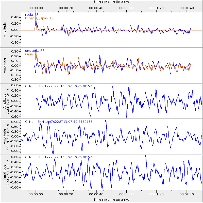
INU Inuyama, Japan - Earthquake Result Viewer
*The percent match for this event was below the threshold and hence no stack was calculated.
| Earthquake location: |
Armenia-Azerbaijan-Iran Bord Reg |
| Earthquake latitude/longitude: |
38.1/48.0 |
| Earthquake time(UTC): |
1997/02/28 (059) 12:57:18 GMT |
| Earthquake Depth: |
10 km |
| Earthquake Magnitude: |
5.5 MB, 6.1 MS, 6.1 UNKNOWN, 6.0 MW |
| Earthquake Catalog/Contributor: |
WHDF/NEIC |
|
| Network: |
G GEOSCOPE |
| Station: |
INU Inuyama, Japan |
| Lat/Lon: |
35.35 N/137.03 E |
| Elevation: |
132 m |
|
| Distance: |
68.6 deg |
| Az: |
61.4 deg |
| Baz: |
302.044 deg |
| Ray Param: |
$rayparam |
*The percent match for this event was below the threshold and hence was not used in the summary stack. |
|
| Radial Match: |
57.178123 % |
| Radial Bump: |
400 |
| Transverse Match: |
53.24738 % |
| Transverse Bump: |
400 |
| SOD ConfigId: |
4480 |
| Insert Time: |
2010-02-26 23:23:16.225 +0000 |
| GWidth: |
2.5 |
| Max Bumps: |
400 |
| Tol: |
0.001 |
|
Signal To Noise
| Channel | StoN | STA | LTA |
| G:INU: :BHN:19970228T13:07:50.253015Z | 2.1577294 | 3.928913E-7 | 1.8208553E-7 |
| G:INU: :BHE:19970228T13:07:50.253015Z | 0.9423409 | 1.4658967E-7 | 1.5555906E-7 |
| G:INU: :BHZ:19970228T13:07:50.253015Z | 1.1184205 | 1.6775094E-7 | 1.4998916E-7 |
| Arrivals |
| Ps | |
| PpPs | |
| PsPs/PpSs | |


