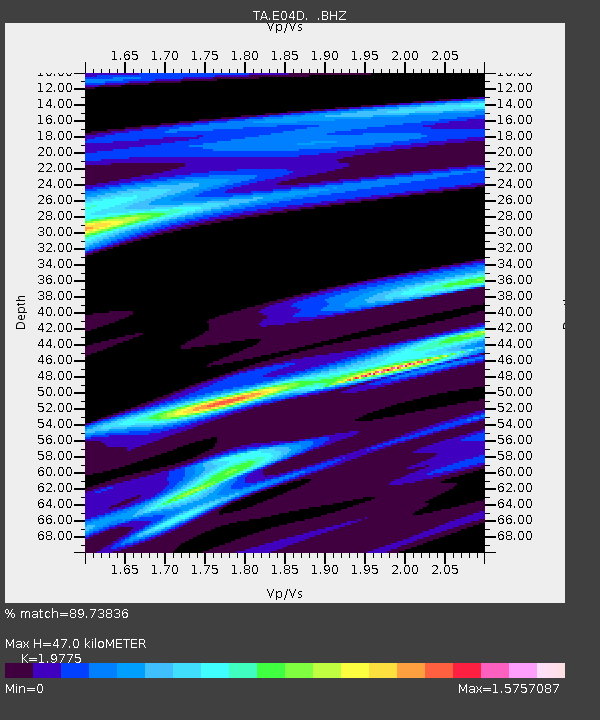
E04D Cinebar, WA, USA - Earthquake Result Viewer

Earthquake location: Near Coast Of Guerrero, Mexico
Earthquake latitude/longitude: 16.5/-98.2
Earthquake time(UTC): 2012/03/20 (080) 18:02:47 GMT
Earthquake Depth: 20 km
Earthquake Magnitude: 6.6 MB, 7.6 MS, 7.4 MW, 7.4 MW
Earthquake Catalog/Contributor: WHDF/NEIC
Network: TA USArray Transportable Network (new EarthScope stations)
Station: E04D Cinebar, WA, USA
Lat/Lon: 46.56 N/122.57 W
Elevation: 204 m
Distance: 36.2 deg
Az: 331.184 deg
Baz: 137.926 deg
Ray Param: 0.07680951
Estimated Moho Depth: 47.0 km
Estimated Crust Vp/Vs: 1.98
Assumed Crust Vp: 6.566 km/s
Estimated Crust Vs: 3.32 km/s
Estimated Crust Poisson's Ratio: 0.33
Radial Match: 89.73836 %
Radial Bump: 292
Transverse Match: 73.59013 %
Transverse Bump: 347
SOD ConfigId: 440406
Insert Time: 2012-06-03 02:38:32.680 +0000
GWidth: 2.5
Max Bumps: 400
Tol: 0.001

Signal To Noise

ChannelStoNSTALTA
TA:E04D: :BHZ:20120320T18:09:17.649991Z10.0447091.2048076E-51.199445E-6
TA:E04D: :BHN:20120320T18:09:17.649991Z3.52799994.3685313E-61.2382458E-6
TA:E04D: :BHE:20120320T18:09:17.649991Z3.27431653.6643107E-61.1191071E-6
Arrivals
Ps7.5 SECOND
PpPs20 SECOND
PsPs/PpSs27 SECOND