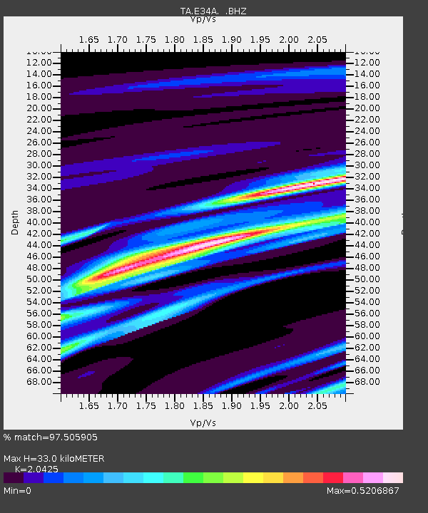
E34A Wadena, MN, USA - Earthquake Result Viewer

Earthquake location: Near Coast Of Guerrero, Mexico
Earthquake latitude/longitude: 16.5/-98.2
Earthquake time(UTC): 2012/03/20 (080) 18:02:47 GMT
Earthquake Depth: 20 km
Earthquake Magnitude: 6.6 MB, 7.6 MS, 7.4 MW, 7.4 MW
Earthquake Catalog/Contributor: WHDF/NEIC
Network: TA USArray Transportable Network (new EarthScope stations)
Station: E34A Wadena, MN, USA
Lat/Lon: 46.51 N/95.17 W
Elevation: 430 m
Distance: 30.0 deg
Az: 4.226 deg
Baz: 185.875 deg
Ray Param: 0.07942396
Estimated Moho Depth: 33.0 km
Estimated Crust Vp/Vs: 2.04
Assumed Crust Vp: 6.419 km/s
Estimated Crust Vs: 3.143 km/s
Estimated Crust Poisson's Ratio: 0.34
Radial Match: 97.505905 %
Radial Bump: 234
Transverse Match: 86.130196 %
Transverse Bump: 400
SOD ConfigId: 440406
Insert Time: 2012-06-03 02:38:35.145 +0000
GWidth: 2.5
Max Bumps: 400
Tol: 0.001

Signal To Noise

ChannelStoNSTALTA
TA:E34A: :BHZ:20120320T18:08:24.475004Z46.8606532.122888E-54.530214E-7
TA:E34A: :BHN:20120320T18:08:24.475004Z68.529341.5000767E-52.1889554E-7
TA:E34A: :BHE:20120320T18:08:24.475004Z6.6449942.5780944E-63.8797543E-7
Arrivals
Ps5.7 SECOND
PpPs15 SECOND
PsPs/PpSs20 SECOND