D37A Cotton, MN, USA - Earthquake Result Viewer
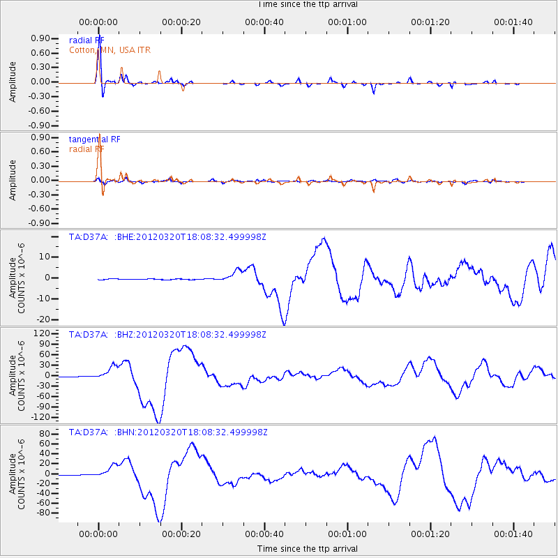
Earthquake location: Near Coast Of Guerrero, Mexico
Earthquake latitude/longitude: 16.5/-98.2
Earthquake time(UTC): 2012/03/20 (080) 18:02:47 GMT
Earthquake Depth: 20 km
Earthquake Magnitude: 6.6 MB, 7.6 MS, 7.4 MW, 7.4 MW
Earthquake Catalog/Contributor: WHDF/NEIC
Network: TA USArray Transportable Network (new EarthScope stations)
Station: D37A Cotton, MN, USA
Lat/Lon: 47.16 N/92.43 W
Elevation: 413 m
Distance: 31.0 deg
Az: 7.712 deg
Baz: 190.874 deg
Ray Param: 0.07918431
Estimated Moho Depth: 17.75 km
Estimated Crust Vp/Vs: 1.71
Assumed Crust Vp: 6.571 km/s
Estimated Crust Vs: 3.842 km/s
Estimated Crust Poisson's Ratio: 0.24
Radial Match: 94.30963 %
Radial Bump: 265
Transverse Match: 79.771904 %
Transverse Bump: 400
SOD ConfigId: 440406
Insert Time: 2012-06-03 02:38:58.632 +0000
GWidth: 2.5
Max Bumps: 400
Tol: 0.001

Signal To Noise

ChannelStoNSTALTA
TA:D37A: :BHZ:20120320T18:08:32.499998Z60.9126742.1187707E-53.4783744E-7
TA:D37A: :BHN:20120320T18:08:32.499998Z39.871391.3643056E-53.4217658E-7
TA:D37A: :BHE:20120320T18:08:32.499998Z16.8512172.9582625E-61.7555186E-7
Arrivals
Ps2.1 SECOND
PpPs6.7 SECOND
PsPs/PpSs8.8 SECOND