C06D Leavenworth, WQ, USA - Earthquake Result Viewer
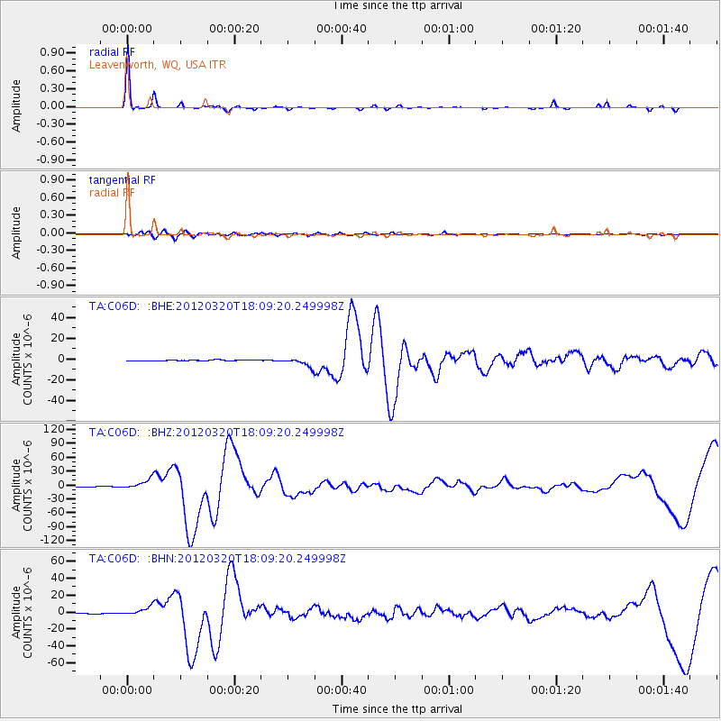
Earthquake location: Near Coast Of Guerrero, Mexico
Earthquake latitude/longitude: 16.5/-98.2
Earthquake time(UTC): 2012/03/20 (080) 18:02:47 GMT
Earthquake Depth: 20 km
Earthquake Magnitude: 6.6 MB, 7.6 MS, 7.4 MW, 7.4 MW
Earthquake Catalog/Contributor: WHDF/NEIC
Network: TA USArray Transportable Network (new EarthScope stations)
Station: C06D Leavenworth, WQ, USA
Lat/Lon: 47.92 N/120.89 W
Elevation: 544 m
Distance: 36.5 deg
Az: 334.146 deg
Baz: 141.537 deg
Ray Param: 0.076642774
Estimated Moho Depth: 33.75 km
Estimated Crust Vp/Vs: 1.93
Assumed Crust Vp: 6.597 km/s
Estimated Crust Vs: 3.423 km/s
Estimated Crust Poisson's Ratio: 0.32
Radial Match: 95.57477 %
Radial Bump: 162
Transverse Match: 82.90768 %
Transverse Bump: 400
SOD ConfigId: 440406
Insert Time: 2012-06-03 02:39:07.278 +0000
GWidth: 2.5
Max Bumps: 400
Tol: 0.001

Signal To Noise

ChannelStoNSTALTA
TA:C06D: :BHZ:20120320T18:09:20.249998Z16.0344961.0895587E-56.795091E-7
TA:C06D: :BHN:20120320T18:09:20.249998Z11.3190914.9666173E-64.387824E-7
TA:C06D: :BHE:20120320T18:09:20.249998Z9.5305184.359171E-64.5739077E-7
Arrivals
Ps5.1 SECOND
PpPs14 SECOND
PsPs/PpSs19 SECOND