You are here: Home > Network List > G - GEOSCOPE Stations List
> Station INU Inuyama, Japan > Earthquake Result Viewer
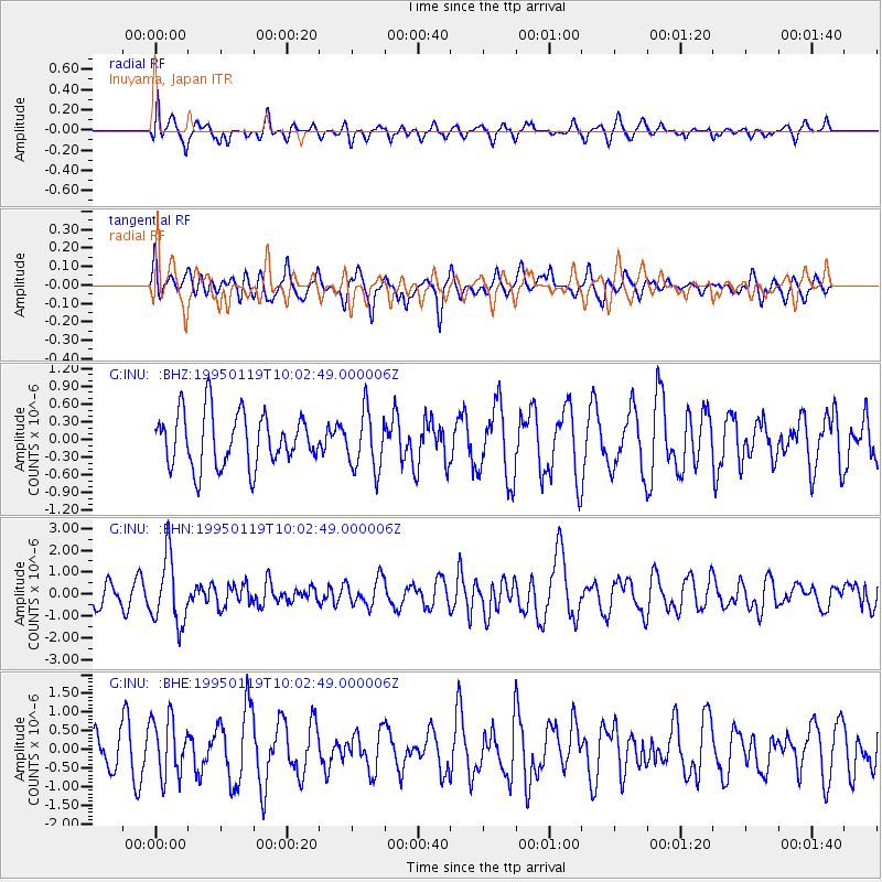
INU Inuyama, Japan - Earthquake Result Viewer
*The percent match for this event was below the threshold and hence no stack was calculated.
| Earthquake location: |
Banda Sea |
| Earthquake latitude/longitude: |
-7.3/128.3 |
| Earthquake time(UTC): |
1995/01/19 (019) 09:55:34 GMT |
| Earthquake Depth: |
170 km |
| Earthquake Magnitude: |
5.8 MB, 6.1 UNKNOWN, 5.9 MW |
| Earthquake Catalog/Contributor: |
WHDF/NEIC |
|
| Network: |
G GEOSCOPE |
| Station: |
INU Inuyama, Japan |
| Lat/Lon: |
35.35 N/137.03 E |
| Elevation: |
132 m |
|
| Distance: |
43.3 deg |
| Az: |
10.464 deg |
| Baz: |
192.731 deg |
| Ray Param: |
$rayparam |
*The percent match for this event was below the threshold and hence was not used in the summary stack. |
|
| Radial Match: |
56.76201 % |
| Radial Bump: |
400 |
| Transverse Match: |
43.573658 % |
| Transverse Bump: |
400 |
| SOD ConfigId: |
4480 |
| Insert Time: |
2010-02-26 23:23:18.852 +0000 |
| GWidth: |
2.5 |
| Max Bumps: |
400 |
| Tol: |
0.001 |
|
Signal To Noise
| Channel | StoN | STA | LTA |
| G:INU: :BHN:19950119T10:02:49.000006Z | 2.6553557 | 1.53963E-6 | 5.798206E-7 |
| G:INU: :BHE:19950119T10:02:49.000006Z | 2.2874722 | 7.778431E-7 | 3.400448E-7 |
| G:INU: :BHZ:19950119T10:02:49.000006Z | 1.1128722 | 4.9690465E-7 | 4.4650645E-7 |
| Arrivals |
| Ps | |
| PpPs | |
| PsPs/PpSs | |


