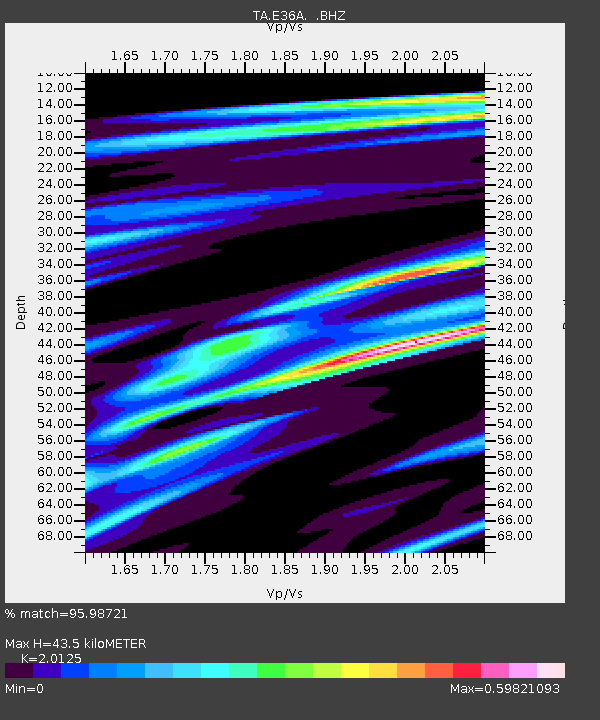
E36A McGregor, MN, USA - Earthquake Result Viewer
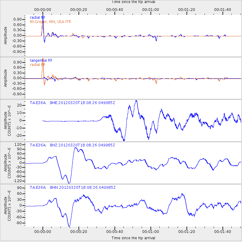
Earthquake location: Near Coast Of Guerrero, Mexico
Earthquake latitude/longitude: 16.5/-98.2
Earthquake time(UTC): 2012/03/20 (080) 18:02:47 GMT
Earthquake Depth: 20 km
Earthquake Magnitude: 6.6 MB, 7.6 MS, 7.4 MW, 7.4 MW
Earthquake Catalog/Contributor: WHDF/NEIC
Network: TA USArray Transportable Network (new EarthScope stations)
Station: E36A McGregor, MN, USA
Lat/Lon: 46.52 N/93.26 W
Elevation: 393 m
Distance: 30.2 deg
Az: 6.833 deg
Baz: 189.514 deg
Ray Param: 0.07937641
Estimated Moho Depth: 43.5 km
Estimated Crust Vp/Vs: 2.01
Assumed Crust Vp: 6.571 km/s
Estimated Crust Vs: 3.265 km/s
Estimated Crust Poisson's Ratio: 0.34
Radial Match: 95.98721 %
Radial Bump: 287
Transverse Match: 91.695404 %
Transverse Bump: 400
SOD ConfigId: 440406
Insert Time: 2012-06-03 02:39:46.228 +0000
GWidth: 2.5
Max Bumps: 400
Tol: 0.001

Signal To Noise

ChannelStoNSTALTA
TA:E36A: :BHZ:20120320T18:08:26.049985Z79.378422.2711565E-52.8611765E-7
TA:E36A: :BHN:20120320T18:08:26.049985Z92.694211.5521697E-51.6745057E-7
TA:E36A: :BHE:20120320T18:08:26.049985Z21.6949083.3023066E-61.5221575E-7
Arrivals
Ps7.2 SECOND
PpPs19 SECOND
PsPs/PpSs26 SECOND