You are here: Home > Network List > G - GEOSCOPE Stations List
> Station INU Inuyama, Japan > Earthquake Result Viewer
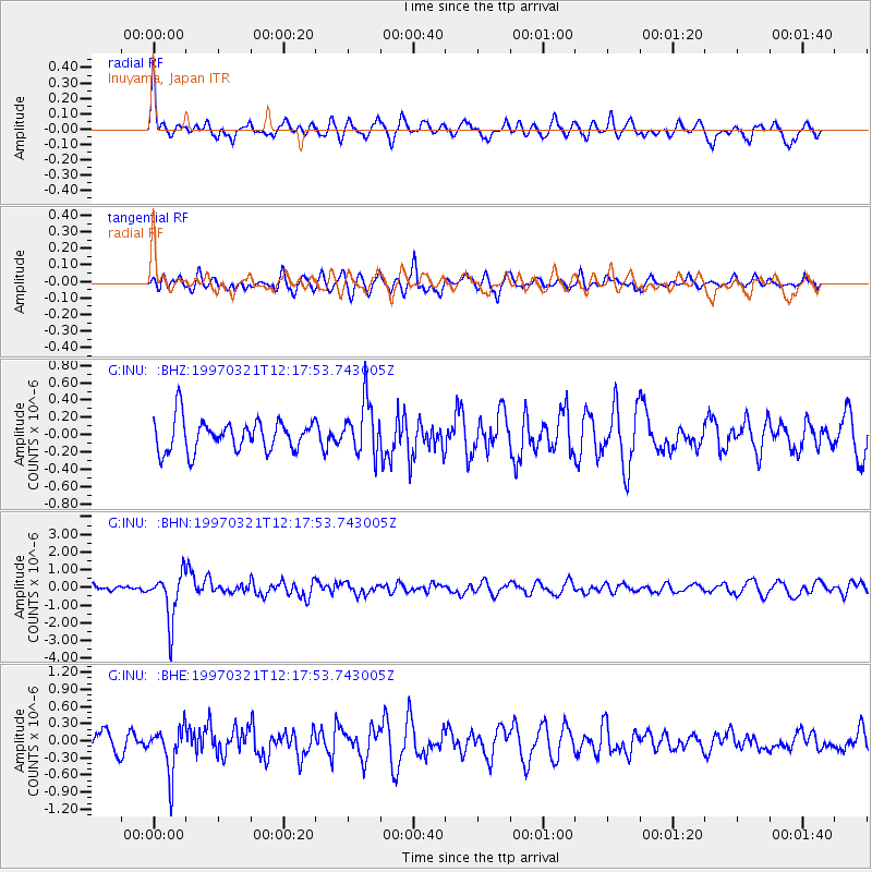
INU Inuyama, Japan - Earthquake Result Viewer
*The percent match for this event was below the threshold and hence no stack was calculated.
| Earthquake location: |
Kermadec Islands Region |
| Earthquake latitude/longitude: |
-31.2/179.6 |
| Earthquake time(UTC): |
1997/03/21 (080) 12:07:17 GMT |
| Earthquake Depth: |
449 km |
| Earthquake Magnitude: |
5.6 MB, 6.3 UNKNOWN, 6.2 MW |
| Earthquake Catalog/Contributor: |
WHDF/NEIC |
|
| Network: |
G GEOSCOPE |
| Station: |
INU Inuyama, Japan |
| Lat/Lon: |
35.35 N/137.03 E |
| Elevation: |
132 m |
|
| Distance: |
77.3 deg |
| Az: |
325.454 deg |
| Baz: |
143.512 deg |
| Ray Param: |
$rayparam |
*The percent match for this event was below the threshold and hence was not used in the summary stack. |
|
| Radial Match: |
76.15307 % |
| Radial Bump: |
400 |
| Transverse Match: |
57.52061 % |
| Transverse Bump: |
400 |
| SOD ConfigId: |
4480 |
| Insert Time: |
2010-02-26 23:23:20.689 +0000 |
| GWidth: |
2.5 |
| Max Bumps: |
400 |
| Tol: |
0.001 |
|
Signal To Noise
| Channel | StoN | STA | LTA |
| G:INU: :BHN:19970321T12:17:53.743005Z | 7.9869013 | 1.3471845E-6 | 1.6867423E-7 |
| G:INU: :BHE:19970321T12:17:53.743005Z | 2.530825 | 4.0648973E-7 | 1.6061551E-7 |
| G:INU: :BHZ:19970321T12:17:53.743005Z | 1.7187089 | 3.1106507E-7 | 1.8098764E-7 |
| Arrivals |
| Ps | |
| PpPs | |
| PsPs/PpSs | |


