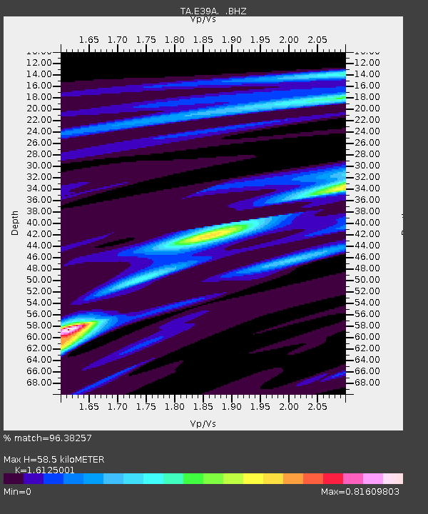
E39A Mellen, WI, USA - Earthquake Result Viewer
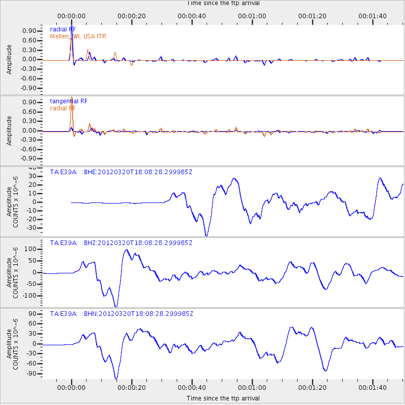
Earthquake location: Near Coast Of Guerrero, Mexico
Earthquake latitude/longitude: 16.5/-98.2
Earthquake time(UTC): 2012/03/20 (080) 18:02:47 GMT
Earthquake Depth: 20 km
Earthquake Magnitude: 6.6 MB, 7.6 MS, 7.4 MW, 7.4 MW
Earthquake Catalog/Contributor: WHDF/NEIC
Network: TA USArray Transportable Network (new EarthScope stations)
Station: E39A Mellen, WI, USA
Lat/Lon: 46.38 N/90.56 W
Elevation: 426 m
Distance: 30.5 deg
Az: 10.505 deg
Baz: 194.634 deg
Ray Param: 0.07930977
Estimated Moho Depth: 58.5 km
Estimated Crust Vp/Vs: 1.61
Assumed Crust Vp: 6.467 km/s
Estimated Crust Vs: 4.01 km/s
Estimated Crust Poisson's Ratio: 0.19
Radial Match: 96.38257 %
Radial Bump: 218
Transverse Match: 87.866196 %
Transverse Bump: 400
SOD ConfigId: 440406
Insert Time: 2012-06-03 02:40:39.230 +0000
GWidth: 2.5
Max Bumps: 400
Tol: 0.001

Signal To Noise

ChannelStoNSTALTA
TA:E39A: :BHZ:20120320T18:08:28.299985Z81.366812.342584E-52.8790413E-7
TA:E39A: :BHN:20120320T18:08:28.299985Z60.856411.48046E-52.4327102E-7
TA:E39A: :BHE:20120320T18:08:28.299985Z20.304245.617912E-62.7668668E-7
Arrivals
Ps6.1 SECOND
PpPs22 SECOND
PsPs/PpSs28 SECOND