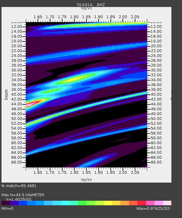
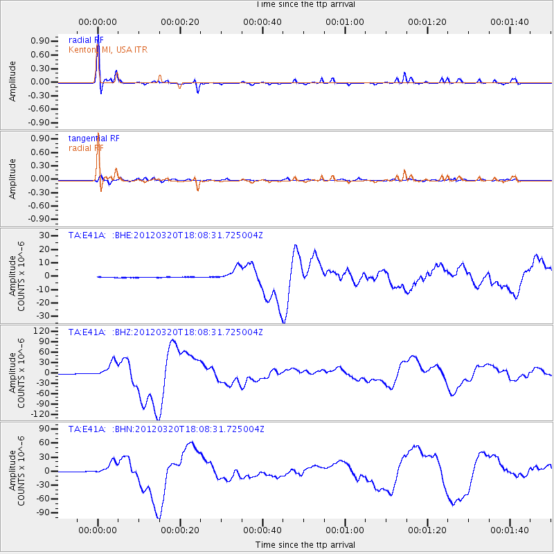
E41A Kenton, MI, USA - Earthquake Result Viewer

Earthquake location: Near Coast Of Guerrero, Mexico
Earthquake latitude/longitude: 16.5/-98.2
Earthquake time(UTC): 2012/03/20 (080) 18:02:47 GMT
Earthquake Depth: 20 km
Earthquake Magnitude: 6.6 MB, 7.6 MS, 7.4 MW, 7.4 MW
Earthquake Catalog/Contributor: WHDF/NEIC
Network: TA USArray Transportable Network (new EarthScope stations)
Station: E41A Kenton, MI, USA
Lat/Lon: 46.46 N/88.96 W
Elevation: 377 m
Distance: 30.9 deg
Az: 12.532 deg
Baz: 197.528 deg
Ray Param: 0.07920776
Estimated Moho Depth: 44.5 km
Estimated Crust Vp/Vs: 1.60
Assumed Crust Vp: 6.467 km/s
Estimated Crust Vs: 4.035 km/s
Estimated Crust Poisson's Ratio: 0.18
Radial Match: 95.4691 %
Radial Bump: 245
Transverse Match: 87.93952 %
Transverse Bump: 400
SOD ConfigId: 440406
Insert Time: 2012-06-03 02:41:01.991 +0000
GWidth: 2.5
Max Bumps: 400
Tol: 0.001

Signal To Noise

ChannelStoNSTALTA
TA:E41A: :BHZ:20120320T18:08:31.725004Z106.2864462.4130422E-52.2703199E-7
TA:E41A: :BHN:20120320T18:08:31.725004Z48.3943821.4526587E-53.001709E-7
TA:E41A: :BHE:20120320T18:08:31.725004Z28.491075.3179406E-61.866529E-7
Arrivals
Ps4.5 SECOND
PpPs16 SECOND
PsPs/PpSs21 SECOND