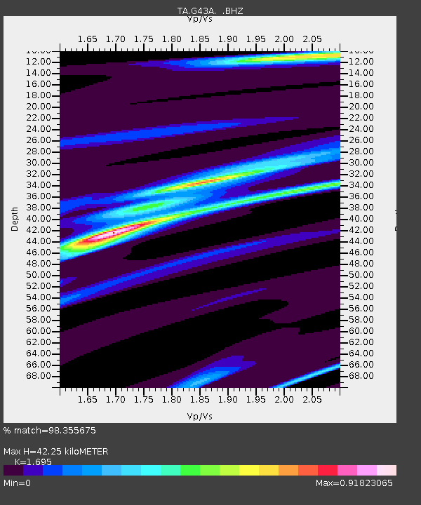
G43A Wallace, MI, USA - Earthquake Result Viewer
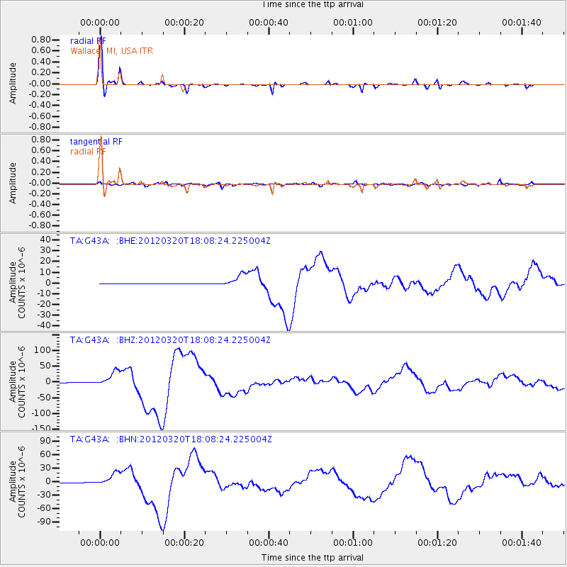
Earthquake location: Near Coast Of Guerrero, Mexico
Earthquake latitude/longitude: 16.5/-98.2
Earthquake time(UTC): 2012/03/20 (080) 18:02:47 GMT
Earthquake Depth: 20 km
Earthquake Magnitude: 6.6 MB, 7.6 MS, 7.4 MW, 7.4 MW
Earthquake Catalog/Contributor: WHDF/NEIC
Network: TA USArray Transportable Network (new EarthScope stations)
Station: G43A Wallace, MI, USA
Lat/Lon: 45.26 N/87.69 W
Elevation: 213 m
Distance: 30.0 deg
Az: 14.976 deg
Baz: 200.548 deg
Ray Param: 0.07943108
Estimated Moho Depth: 42.25 km
Estimated Crust Vp/Vs: 1.70
Assumed Crust Vp: 6.53 km/s
Estimated Crust Vs: 3.853 km/s
Estimated Crust Poisson's Ratio: 0.23
Radial Match: 98.355675 %
Radial Bump: 259
Transverse Match: 85.715546 %
Transverse Bump: 400
SOD ConfigId: 440406
Insert Time: 2012-06-03 02:41:16.197 +0000
GWidth: 2.5
Max Bumps: 400
Tol: 0.001

Signal To Noise

ChannelStoNSTALTA
TA:G43A: :BHZ:20120320T18:08:24.225004Z109.786462.4882296E-52.2664267E-7
TA:G43A: :BHN:20120320T18:08:24.225004Z82.313611.5499447E-51.882975E-7
TA:G43A: :BHE:20120320T18:08:24.225004Z52.484326.3721964E-61.2141143E-7
Arrivals
Ps4.9 SECOND
PpPs16 SECOND
PsPs/PpSs21 SECOND