You are here: Home > Network List > TA - USArray Transportable Network (new EarthScope stations) Stations List
> Station E45A Wooded Hills, Hulbert, MI, USA > Earthquake Result Viewer
E45A Wooded Hills, Hulbert, MI, USA - Earthquake Result Viewer
| Earthquake location: |
Near Coast Of Guerrero, Mexico |
| Earthquake latitude/longitude: |
16.5/-98.2 |
| Earthquake time(UTC): |
2012/03/20 (080) 18:02:47 GMT |
| Earthquake Depth: |
20 km |
| Earthquake Magnitude: |
6.6 MB, 7.6 MS, 7.4 MW, 7.4 MW |
| Earthquake Catalog/Contributor: |
WHDF/NEIC |
|
| Network: |
TA USArray Transportable Network (new EarthScope stations) |
| Station: |
E45A Wooded Hills, Hulbert, MI, USA |
| Lat/Lon: |
46.36 N/85.18 W |
| Elevation: |
251 m |
|
| Distance: |
31.7 deg |
| Az: |
17.319 deg |
| Baz: |
204.353 deg |
| Ray Param: |
0.07894561 |
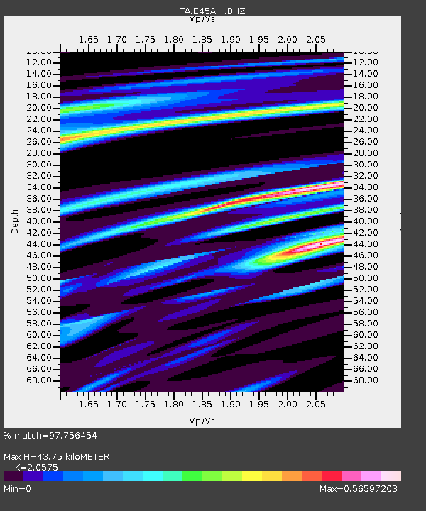
| Estimated Moho Depth: |
43.75 km |
| Estimated Crust Vp/Vs: |
2.06 |
| Assumed Crust Vp: |
6.467 km/s |
| Estimated Crust Vs: |
3.143 km/s |
| Estimated Crust Poisson's Ratio: |
0.35 |
|
| Radial Match: |
97.756454 % |
| Radial Bump: |
220 |
| Transverse Match: |
85.981514 % |
| Transverse Bump: |
400 |
| SOD ConfigId: |
440406 |
| Insert Time: |
2012-06-03 02:41:36.252 +0000 |
| GWidth: |
2.5 |
| Max Bumps: |
400 |
| Tol: |
0.001 |
|

Signal To Noise
| Channel | StoN | STA | LTA |
| TA:E45A: :BHZ:20120320T18:08:39.07501Z | 75.053215 | 2.6837613E-5 | 3.5758111E-7 |
| TA:E45A: :BHN:20120320T18:08:39.07501Z | 32.879528 | 1.5861699E-5 | 4.824186E-7 |
| TA:E45A: :BHE:20120320T18:08:39.07501Z | 14.576698 | 8.153344E-6 | 5.59341E-7 |
| Arrivals |
| Ps | 7.7 SECOND |
| PpPs | 19 SECOND |
| PsPs/PpSs | 27 SECOND |


