You are here: Home > Network List > TA - USArray Transportable Network (new EarthScope stations) Stations List
> Station F45A CMU Biological Station, Beaver Island, MI, USA > Earthquake Result Viewer
F45A CMU Biological Station, Beaver Island, MI, USA - Earthquake Result Viewer

| Earthquake location: |
Near Coast Of Guerrero, Mexico |
| Earthquake latitude/longitude: |
16.5/-98.2 |
| Earthquake time(UTC): |
2012/03/20 (080) 18:02:47 GMT |
| Earthquake Depth: |
20 km |
| Earthquake Magnitude: |
6.6 MB, 7.6 MS, 7.4 MW, 7.4 MW |
| Earthquake Catalog/Contributor: |
WHDF/NEIC |
|
| Network: |
TA USArray Transportable Network (new EarthScope stations) |
| Station: |
F45A CMU Biological Station, Beaver Island, MI, USA |
| Lat/Lon: |
45.68 N/85.52 W |
| Elevation: |
173 m |
|
| Distance: |
31.0 deg |
| Az: |
17.438 deg |
| Baz: |
204.212 deg |
| Ray Param: |
0.079174705 |
| Estimated Moho Depth: |
34.25 km |
| Estimated Crust Vp/Vs: |
2.01 |
| Assumed Crust Vp: |
6.483 km/s |
| Estimated Crust Vs: |
3.233 km/s |
| Estimated Crust Poisson's Ratio: |
0.33 |
|
| Radial Match: |
97.28684 % |
| Radial Bump: |
280 |
| Transverse Match: |
85.17867 % |
| Transverse Bump: |
400 |
| SOD ConfigId: |
440406 |
| Insert Time: |
2012-06-03 02:41:47.635 +0000 |
| GWidth: |
2.5 |
| Max Bumps: |
400 |
| Tol: |
0.001 |
|
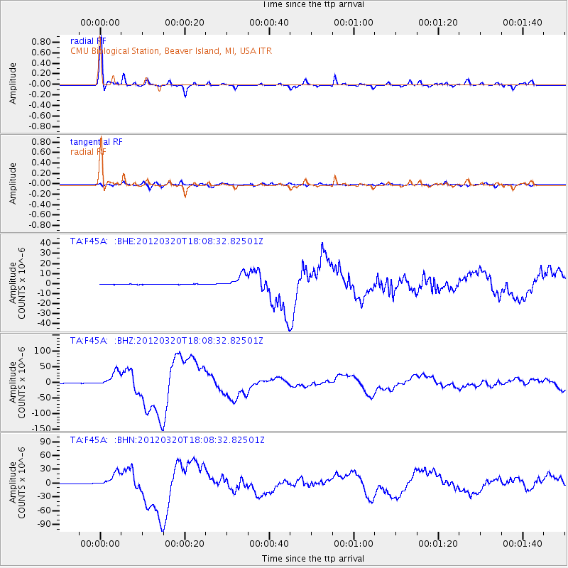
Signal To Noise
| Channel | StoN | STA | LTA |
| TA:F45A: :BHZ:20120320T18:08:32.82501Z | 76.992256 | 2.4992698E-5 | 3.2461313E-7 |
| TA:F45A: :BHN:20120320T18:08:32.82501Z | 56.277817 | 1.590323E-5 | 2.8258435E-7 |
| TA:F45A: :BHE:20120320T18:08:32.82501Z | 34.487473 | 7.1713634E-6 | 2.0794111E-7 |
| Arrivals |
| Ps | 5.7 SECOND |
| PpPs | 15 SECOND |
| PsPs/PpSs | 20 SECOND |


