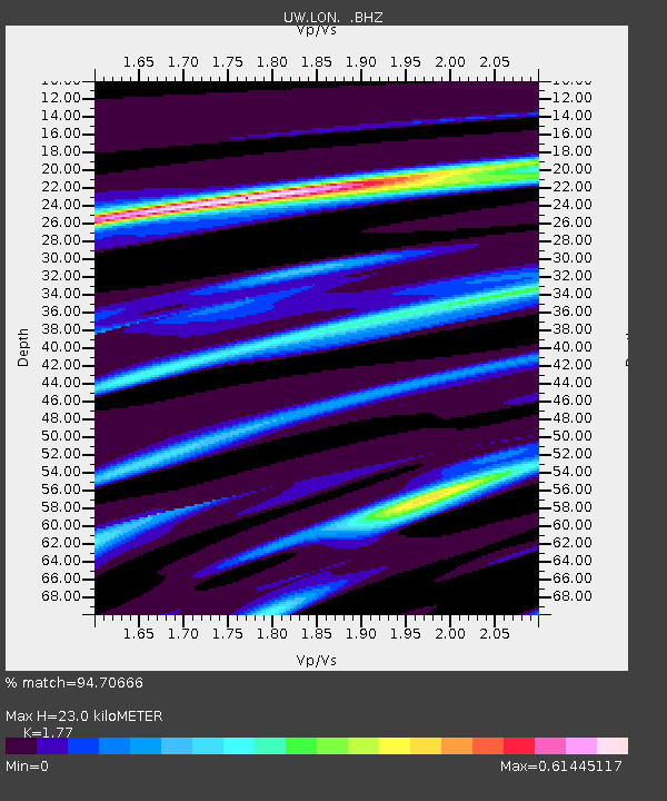
LON Longmire (broad-band and DWWSSN) - Earthquake Result Viewer
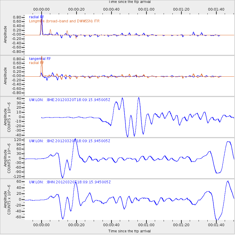
Earthquake location: Near Coast Of Guerrero, Mexico
Earthquake latitude/longitude: 16.5/-98.2
Earthquake time(UTC): 2012/03/20 (080) 18:02:47 GMT
Earthquake Depth: 20 km
Earthquake Magnitude: 6.6 MB, 7.6 MS, 7.4 MW, 7.4 MW
Earthquake Catalog/Contributor: WHDF/NEIC
Network: UW Pacific Northwest Regional Seismic Network
Station: LON Longmire (broad-band and DWWSSN)
Lat/Lon: 46.75 N/121.81 W
Elevation: 850 m
Distance: 36.0 deg
Az: 332.066 deg
Baz: 139.188 deg
Ray Param: 0.07691856
Estimated Moho Depth: 23.0 km
Estimated Crust Vp/Vs: 1.77
Assumed Crust Vp: 6.597 km/s
Estimated Crust Vs: 3.727 km/s
Estimated Crust Poisson's Ratio: 0.27
Radial Match: 94.70666 %
Radial Bump: 218
Transverse Match: 90.14088 %
Transverse Bump: 289
SOD ConfigId: 440406
Insert Time: 2012-06-03 02:42:15.938 +0000
GWidth: 2.5
Max Bumps: 400
Tol: 0.001

Signal To Noise

ChannelStoNSTALTA
UW:LON: :BHZ:20120320T18:09:15.945005Z16.0534279.012548E-65.614096E-7
UW:LON: :BHN:20120320T18:09:15.945005Z10.754164.136395E-63.8463207E-7
UW:LON: :BHE:20120320T18:09:15.945005Z4.99639942.8695279E-65.743192E-7
Arrivals
Ps2.9 SECOND
PpPs8.9 SECOND
PsPs/PpSs12 SECOND