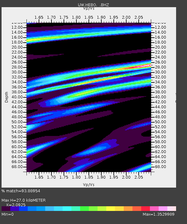
HEBO Mt. Hebo, OR CREST BB SMO - Earthquake Result Viewer

Earthquake location: Near Coast Of Guerrero, Mexico
Earthquake latitude/longitude: 16.5/-98.2
Earthquake time(UTC): 2012/03/20 (080) 18:02:47 GMT
Earthquake Depth: 20 km
Earthquake Magnitude: 6.6 MB, 7.6 MS, 7.4 MW, 7.4 MW
Earthquake Catalog/Contributor: WHDF/NEIC
Network: UW Pacific Northwest Regional Seismic Network
Station: HEBO Mt. Hebo, OR CREST BB SMO
Lat/Lon: 45.21 N/123.76 W
Elevation: 875 m
Distance: 35.8 deg
Az: 328.584 deg
Baz: 134.97 deg
Ray Param: 0.07702832
Estimated Moho Depth: 27.0 km
Estimated Crust Vp/Vs: 2.09
Assumed Crust Vp: 6.566 km/s
Estimated Crust Vs: 3.138 km/s
Estimated Crust Poisson's Ratio: 0.35
Radial Match: 93.88954 %
Radial Bump: 306
Transverse Match: 82.26241 %
Transverse Bump: 400
SOD ConfigId: 440406
Insert Time: 2012-06-03 02:42:42.530 +0000
GWidth: 2.5
Max Bumps: 400
Tol: 0.001

Signal To Noise

ChannelStoNSTALTA
UW:HEBO: :BHZ:20120320T18:09:14.209989Z5.84971488.956075E-61.5310276E-6
UW:HEBO: :BHN:20120320T18:09:14.209989Z1.73383453.5629694E-62.054965E-6
UW:HEBO: :BHE:20120320T18:09:14.209989Z1.62377073.756609E-62.3135094E-6
Arrivals
Ps4.8 SECOND
PpPs12 SECOND
PsPs/PpSs17 SECOND